Showing posts with label Friday Field Foto. Show all posts

Friday, August 24, 2007

Friday Field Foto #27: Cretaceous marine shale


I was browsing my collection of photographs this morning looking for a Friday Field Foto and, as happens when you start looking at old photos, I was reminded of when we were doing this field work. Today's photo is from the Cretaceous of central Utah (the Book Cliffs). When I was working on my master's in Colorado we took many field trips in the western Colorado and east-central Utah. I've shown some photos from the Book Cliffs before (here, here, and here).

What's obvious in the photo is the cliff-forming sandstone unit capping the mesa. These strata represent the movement of the ancient shoreline through the area. The underlying thick shale sequence (the drab, slope-forming gray 'rocks') are offshore marine deposits. If you look closely (click on the image to get a better view*), you'll notice a darker gray path heading up the gray slope to the base of the sandstone cliff. Me and another guy measured a stratigraphic section and took some samples up that hill. We were out here helping out another student and this was supplemental data for him....he was trying to look at the nature of the marine shale over a thick sequence.

This falls into the category of "hey, whatever happened to that data?"


*I'm pretty unhappy with the quality of embedded images in Blogger. One shouldn't have to click on an image to get a better view. Photos on other blogs, WordPress for example, tend to look much crisper. Maybe i'm just being anal. If anyone has any positive or negative comments about WordPress and/or migrating a Blogger blog to WordPress, please comment below.

Thursday, August 16, 2007

Friday Field Foto #26: Birds on a corral fence

I snapped this photo of some ibis this past March after a long horse ride out of the woods. Happy Friday!

Friday, August 10, 2007

Friday Field Foto #25: Ancient organic detritus

Many modern river delta environments are chock full of organic matter (think Louisiana swamp). Much of it is plant and other woody material. In some cases, this material is buried and remnants or evidence of it are preserved when the sediment lithifies.


The photos above show the bedding plane view (looking down on top of the surface of sedimentary layer) of a deposit rich with organic detritus (i.e., pieces of stuff). A lot of it is preserved woody fragments. Also note the dark black flecks...this material is mostly carbonaceous shale, which is kind of like coal. Click on these to see the high-res versions.

The organic detritus is abundant in thin (~1 cm) layers. The photo below is a cross-sectional view where you can see the layering of the sedimentary rock. The darkest layers (the pencil is pointing to one) are dark in color because they are full of this organic detritus and coaly bits.


But, wait, these are turbidites? It says so in the post label. How can you have all this terrestrial organic matter on the deep sea floor? In this case, this turbidite system is being fed by a delta. In the upper photographs, notice how broken up all the organic matter is. It has been ripped up and flushed off the delta environment and into the deep sea, where it was likely buried rather quickly. We find abundant organic detritus on the very tops of turbidite beds....this material is relatively light compared to the medium-grained sand and, therefore, is deposited after the sand as the flow slows down (ending up on top).

The organic detritus-rich nature is, in fact, one of many lines of evidence telling us that these Cretaceous strata are delta-fed turbidite deposits.

Friday, July 27, 2007

Friday Field Foto #24: Conglomerate injectites

I don't have a lot of time right now...still traveling...but wanted to get this Friday Field Foto posted while I wait for my flight (hopefully a better experience than the trip here). I'm not traveling at all for the next 5 weeks, so I should be blogging more frequently (and finishing my dissertation).

A paper I'm a co-author on just came out, which I will post about in more detail next week. The photo above (that's me for scale) is a great view of some conglomerate injectites in Cretaceous sedimentary rocks down in Patagonia. I showed a photo of some smaller injectites previously on this blog.

Note the flat lying shale and thin-bedded sandstone that I am standing on juxstaposed against a more resistant conglomeratic body that is nearly vertical.

That must be a fault, right? Wrong. I know this may sound crazy, but this feature represents the upward injection of coarse-grained material through the overlying deposits. Yeah....right. Give me a few days and I'll put together a better explanation of all this. It's pretty wild stuff.

Friday, July 13, 2007

Friday Field Foto #23: Flame structures


Today, we have another sedimentary structure commonly seen in turbidite successions. The features above that look like flames are called.......drum roll........ flame structures (brilliant!). Right in the center of the photograph notice the slightly darker and curved lines in the rock. They meet upwards at a tip and are pointing to the right.

Flame structures form as the upper part sinks into the underlying sediment, often referred to as 'loading'. This loading commonly occurs in localized pods and then the sediment in between gets squeezed up a bit. The directional component of this (the tip of the 'flame') is produced because there is still some current strength which shears the material just slightly before everything comes to rest as a deposit. So, in the case above the local current direction was left to right.

How does loading occur in the first place?
Firstly, the underlying bed cannot be completely dewatered. That is, it is still a mixture of sediment and water is likely in a 'soupy' state. Secondly, there needs to be a density contrast. The overlying material has to sink into the soupy bed to be able to displace the material like this. You may have seen flame structures before where coarser material (usually sand) sinks into much finer-grained material. But, in this case all the material is sand of similar grain size. The density contrast is set up because the overlying sediment has much more water in it still. Remember, sediment gravity flows are a mixture of sediment in suspension and water....this is very different than fluid flows where the sand is transported as bedload.

So, what does this tell us?
In this case, if you were to examine this deposit laterally away from where this photo was taken the loading and flame structures disappear and the bed is completely homogeneous. This is just a localized structure within a bed and not a boundary between discrete events. Turbidity currents commonly exhibit 'surging' behavior. As the flow moves down-slope it will begin to separate into multiple sub-flows. Or so we think....our knowledge of how these things actually work is incredibly limited.

Friday, July 06, 2007

Friday Field Foto #22: Rip-up clasts

More turbidites!

I'm actually going to visit these rocks early next week for a couple days. This is north of the Bay Area near the charming little coastal town of Gualala (which is fun to say out loud).

In this photo (note coin for scale) we see a complex mixture of pebbly sandstone (near bottom), coarse sandstone, and siltstone and mudstone (darker-colored rock). Note how the coarse sandstone seems to surround the large area of dark mudstone. The mudstone areas are actually clasts within a thick (>5 m) sandy turbidite bed. We call these "rip-up clasts" as they were deposits on the sea floor that were ripped up by a subsequent turbidity current, incorporated into the flow as a clast, and eventually deposited. Muddy material can be quite cohesive and can stay together as a coherent clast like this. Think about making a mudball vs. a sandball with your hands. The sand disaggregates much easier.

As mudstone rip-up clasts go, these are probably slightly above average in size. We commonly see smaller (centimeter scale) and once in a while you'll see a deposit with larger rip-up clasts.

Friday, June 15, 2007

Friday Field Foto #21: Climbing ripples

Today we are gonna look at some ripple cross-laminated sandstone. More specifically these are called 'climbing ripples', or sometimes you may see this sedimentary structure referred to as 'ripple drift'. These show up particularly nice in this photo because of the light-dark contrast of the sandy vs. muddy laminae.

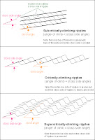
Climbing ripples record both migration (lateral) and aggradation (vertical) of the bedform. In this example note the very prominent ripple set in the middle section of the photo nicely showing the 'climb' from left to right. Different angles of climb represent different ratios of migration and aggradation. Climbing ripples are commonly interbedded with or grade upwards into wavy laminae.


This image at left is a classification of types of climbing ripple-laminated structures based on the angle of climb (click on image for larger view; click here for source of image).

Climbing ripples are most commonly seen in river and turbidity current deposits, typically in sub-environments of high rates of deposition from decelerating flows.


On a side note, Dr. Lemming has pointed out a new geology-related blog out there. It's called All of My Faults Are Stress Related and looks to be a nice addition to the geoblogosphere. I have a few more new links over there on the sidebar that i'll post about soon.

I also have an updated album of Patagonia photos you can check out here. The above image is from that collection.

Friday, June 08, 2007

Friday Field Foto #20: Volcanic hills

Last weekend our research group along with some others went on a short field trip that was a cross-section of the California convergent margin. We were principally looking at the Mesozoic system -- the continental arc plutons of the Sierra Nevada, the sedimentary rocks of the adjacent forearc basin (Great Valley Group), and then the deformed cherts, pillow lavas, and greenstones of the Franciscan subduction complex. Normally, the forearc and accretionary prism do not get well preserved, but thanks to the transition from a subduction margin to a strike-slip margin (San Andreas Fault system), these major elements of the Mesozoic system are preserved in their general relative positions for us to examine.

Although we focused on the Mesozoic system, we looked at many of the younger features along this transect as well. This week's photo is of Sutter Buttes, or sometimes known as Marysville Buttes. This hills are sticking out of the middle of the fantastically flat Central Valley like a giant zit on a teenager's forehead.


Below is a very general geologic map of this part of California pointing out the location of Sutter Buttes.

So, what are these hills all about? They consist of rhyolites and andesites that were erupted about 1.5 million years ago. This young and small volcanic complex appears to be part of the Cascade system. Mt. Lassen, which is ~100 miles to the north of Sutter Buttes, is the southernmost volcano of the Cascade arc to have erupted in historical times. There is some debate about the position of Sutter Buttes with respect to the northward migrating triple junction and associated timing of cessation of volcanism. Some of these questions remain unanswered.

If you ever find yourself in the Great Valley and are feeling topographically-deficient, go check out the Buttes.

Thursday, May 31, 2007

Friday Field Foto #19: Trough cross-bedding

I'm puttin' these up a day early because we are actually going on a 4-day field trip starting tomorrow. Yay!This photo is a shot looking down on the bedding plane of cross-bedded sandstone. The pencil is in the area between two migrating arcuate dunes. If you're lucky enough to get a bedding plane exposure of cross-stratified deposits you can use them as paleocurrent indicators. In this case, the pencil is pointing downstream.
This is in a shallow-marine unit of the Cretaceous in central Utah.


All Friday Field Fotos are taken by me unless otherwise noted.

Friday, May 25, 2007

Friday Field Foto #18: Lousy outcrop

Unfortunately, this has been my 'field site' for the last several weeks...depressing.
I'm jealous of those who are out there looking at rocks in their natural habitat right now. But, we have a long weekend field trip coming up next week!

Friday, May 18, 2007

Friday Field Foto #17: Clast imbrication

Today's field photograph comes from the Valley of Fire region in Nevada. A few years ago we organized a student-led field trip to this area to check out some of the fantastic geology on display.

This particular photo shows nice clast imbrication in a Cretaceous alluvial fan sequence. Note the three clasts just below the pencil stacked on each other showing the paleocurrent direction to the right. If you go hike around on a modern alluvial fan or stream with cobbles in it, you will likely find small piles of imbricated clasts just like this.

Friday, May 11, 2007

Friday Field Foto #16: Sand injectites

Okay, back to Patagonia for this week's photo.


This isn't in my specific field area, but very close to it and in the same formation. What's really cool about this area is the presence of clastic dikes....or, what have now been termed "injectites", as in the injection of sand. In this photo you'll notice the light-colored streaks cutting up and to the right across the flat-lying strata. These features are sandstone.

Injectites have been recognized for over a hundred years, but have been more appreciated in recent years. Oil companies searching for petroleum in the North Sea have seen huge networks and complexes of injectites with seismic-reflection data. And I mean huge...some of the individual sandstone "dikes" can be kilometers long cutting sub-vertically through the strata.

In the case above, the orientation of this swarm of injectites are parallel to a growth fault (i.e., syn-depositional) lower in the section.

There is still much debate about the mechanics of these things...what kinds of overpressures are required, how fast is the unlithified sand injected, and so on.

Friday, May 04, 2007

Friday Field Foto #15: Pillow basalts

One of the best parts about living in the San Francisco Bay Area is that there is great geology very close by. I snapped this photo just a couple weeks ago when we showing some out-of-town visitors around the area.

These beautiful pillow basalts are exposed out at Point Bonita, which is the most seaward promontory adjacent to the Golden Gate. Barely visible is a seagull in the upper left corner of the photo for scale. This area is part of the Marin Headlands, which is composed of rocks of the Franciscan accretionary complex. Very near to this site are spectacularly folded radiolarian cherts.

In addition to the pillow basalts, which are obviously the main attraction, there is a cool old lighthouse.

Friday, April 27, 2007

Friday Field Foto #14: Landslide deposit


In the spring of 2006 I was lucky enough to attend a geology conference in Mendoza, Argentina, which is in the foreland of the central Andes east of, and just over the continental divide from Santiago, Chile. Part of the program was a day trip up to the Andes to look at the fold-thrust belt structure. This is very close to Aconcagua, which is the highest peak in the western hemisphere (almost 7,000 meters).

I snapped this photo on the last stop of the day (near the divide/border) of a landslide that occured about 100 years ago. Apparently, the timing of this is known from notes and observations from European explorers/settlers. Note the building in the lower right foreground for scale.

Friday, April 20, 2007

Friday Field Foto #13: Permian rocks of the Delaware Mts

This is from west Texas (my old master's degree stompin' grounds). The Permian Brushy Canyon Formation is the sandstone and siltstone making up the foreground cliffs. In the background, along the skyline, is the Guadalupe Mountains, which is the highest point in Texas.

The geology of this area is very unique in that these mountains expose a shelf, shelf-margin, and basin transition across ~100 km nearly continuously. One of these days, I'll post some more info about that.

This photo taken by and courtesy of my friend Marieke

Friday, April 13, 2007

Friday Field Foto #12: Combined-flow ripples

I realized today that I haven't done a Friday Field Foto since early February...go here to see all the previous FFF posts.

Today, I decided to show a close-up instead of the usual landscape-scale views that I usually post. This is from the Cretaceous of central Utah (associated w/ these rocks) and shows some very nice ripple cross-laminated sandstone. In this case you can very nicely see some slightly climbing ripple-laminated sandstone toward the bottom overlain by some ripples heading the other way (apparently), and then some wavy laminae and smaller-scale ripples on top. Above and below this bed are abundant hummocky cross-stratified sandstones indicating that these ripple-laminated deposits are likely the product of combined flow (oscillatory + unidirectional) associated with storm waves (i.e., between storm- and fair weather-wave base).

Friday, February 16, 2007

Friday Field Foto #11: Guanaco

I am headed down south again very soon (next Tues) for my last field season in Patagonia...as a student anyway. I've had one other post about wildlife we encounter down there.

The above animal is a guanaco, which is sort of like a cross between a llama and a camel. These things are all over the place. We were able to get close to this particular one because we were in Parque Nacional Torres del Paine, where they are tamer. When we see them in other areas outside of the park, they keep their distance. Typically one of them will stand between us and the rest of the herd...keeping the herd informed on what we are doing. Guanacos make a noise that sounds like a horse whinney combined with a laughing hyena.

Whenever we see them, we wish we could ride them up the mountain...they can get up the hills a lot faster than us.

Friday, February 02, 2007

Friday Field Foto(s) #10: Turbidites in the French Alps


Instead of one photo this week, i'm gonna show a series of photos from a trip I took to southeastern France last June. Most of my research is involved with characterizing and understanding the deposits of turbidity currents, or turbidites. Essentially, picture an underwater 'avalanche' of sand and mud. The sediment travels down a slope into the deep water in fast-moving turbulent flows. Additionally, this very outcrop is where, in the late 1950s Arnold Bouma developed what has come to be known as the 'Bouma sequence'.


The photo above and to the right is a succession of alternating sandstone beds and mudstone beds (note trees for scale).


A road snaked its way up this mountain so we were able to look the rocks in more detail in the well-exposed roadcuts.

This photo shows the character of bedding at a scale of a few meters. The thicker sand beds are typically a little coarser-grained and tend to be more resistant and stick out of the cliff. The finer-grained material is commonly in thinner beds and more recessive.

Statistics of bed thickness patterns have been done for many years on turbidites. The variability is so great from place to place that there doesn't seem to be a very systematic pattern. Some workers have documented some interesting relationships (Talling, 2001 has a good summary of this).


A lot of turbidite sequences include intervals of chaotically deformed material. It may look like good ol' tectonic deformation but it is the result of slumping and sliding of material on the sea floor. In steeper areas of the slope leading to the deep sea, material that was deposited may sluff
off as submarine landslides. The blocks can stay
relatively intact in many cases.


Here's a larger-scale view of a famous outcrop called Chalufy (note trees for scale). This face is cool because you can see the sand-rich bodies pinching out into the blue-gray fine-grained rock. If you notice there are two distinct sand intervals that successively pinch out as wedge shapes from left to right.

This represents the edge of the deep-marine basin. A series of sand-laden turbidity currents came down the slope and incrementally deposited material that started filling in this hole. This kind of complex stratigraphy is more the rule than the exception. These are not simple layers. These flows both create and respond to sea-floor morphology with channels, levees, fans...you name it. The challenge is to take a preserved ancient succession like this and interpret the processes and morphology that existed on the sea floor. From there we build up and start to understand how the basin filled, what controlled the patterns, and relate it to the tectonic evolution.

I'll be posting a bunch of web resources for turbidite research soon....still working on that.

Friday, January 26, 2007

Friday Field Foto #9: Igneous intrusion cutting across folded strata

This week...another photo from Chile.

Here we got a good ol' geologic puzzle...the kind you'd learn in an intro class. Here we can use the intuitive law of cross-cutting relationships to determine the relative timing of events. First the sediments were deposited, then the lithified sediments (rocks) were uplifted and folded, then an igneous intrusion cuts across the fold. Finally, erosion reveals it all for us to see.

To see all the Friday Field Fotos, go here.
To see more photos of Patagonia, go here.

Friday, January 19, 2007

Friday Field Foto #8: Cretaceous shoreline deposits

I've missed the last few Fridays...

The Book Cliffs are in central Utah and western Colorado and are famous for their spectacular outcrops of Cretaceous shoreline deposits. The seaway, which once stretched across the whole of North America from the Gulf of Mexico to the Arctic Ocean, left a fantastic record of relative sea level changes in these sedimentary rocks. The landward or basinward movement of the shoreline can be mapped along the Book Cliffs by identifying the various sedimentary environments (coastal plain, beach, shoreface, shelf, etc.) in the record.

The map above illustrates this paleogeography nicely. Note how much of Colorado is part of this seaway at this time. Eventually, the rivers and shorelines (as recorded by the stratigraphy) march across Colorado too. This image taken from a fantastic website by geologist Ron Blakey at the University of Northern Arizona. Check it out.