Tuesday, August 28, 2007

Big changes for "...Or Something"

THIS BLOG IS NOW CALLED CLASTIC DETRITUS AND HAS MOVED TO: http://clasticdetritus.com/


I have done it ... I made the big switch from Blogger (blogspot) to WordPress.

I took this opportunity to also rename my blog. I pondered a long time if a "rebranding" was a good idea or not. I've focused much of my blogging on Earth science, and sedimentary geology in particular, over the course of the life of ...Or Something. That name doesn't really represent what this blog is really about (plus, then I get to choose a geeky name).

So, the new name is .... drum roll ... Clastic Detritus


The new URL is: http://clasticdetritus.com/
The new feed is: http://clasticdetritus.com/feed


Hopefully this won't cause too many problems. I know some of you receive my posts via feed aggregators (e.g., GoogleReader) so you will have to update that (sorry). I guess you'll have to update your blogroll lists as well (sorry sorry).


Why the switch to WordPress?

  • Wordpress.com allows you to use your own domain but still host it through them. Although I had to purchase the domain ($15/yr), I feel that having my own is better in the long run.
  • I've never been fond of how commenting is done in Blogger. It is often clunky and inefficient.
  • I like the idea of having static pages associated with the blog (the tabs on the bottom of the header image).
  • I like the look and feel of WordPress much better. When it comes to aesthetics everyone has their own preferences.
  • The navigation for managing the posts, pages, and comments is also better (in my view).

I also felt the timing of changing the name would be better combined with the blogging software switch. The migration was relatively painless. All the posts and comments made it over, although I haven't gone through everything yet. I will write a post about that soon.

The new URL is: http://clasticdetritus.com/
The new feed is: http://clasticdetritus.com/feed


This whole switch-over is happening at the same time as The Accretionary Wedge gets under way but I don't foresee any problems.

A call for posts for the inaugural edition of The Accretionary Wedge: Why do you study geology?

As of 8/28/07: ...Or Something is now called CLASTIC DETRITUS and has moved to: http://clasticdetritus.com/

You can find this post exactly as it is below here. Kindly put any comments there, but I will be checking both to make sure nothing is missed. Thanks!

This move does not affect The Accretionary Wedge geology carnival...it will simply be hosted at my new blog (which is pretty much the same as this blog). Sorry for any confusion or hassles!

--------------------------

If you are first hearing about the geology blog carnival, read this post and associated comments first.

We are organizing a geology blog carnival called The Accretionary Wedge.
What is it and how does it work?

  • write a post related to the chosen theme
  • one blogger will collect the posts and then distribute/announce
  • there will be a different host each edition (me for this one)
  • looks like about once a month (more-or-less) is a good frequency

Okay, so for the inaugural edition of The Accretionary Wedge we have come to a consensus that it would be a good idea to introduce ourselves to each other and the blogosphere at large by writing about why you study geology in the first place. What aspect of Earth/planetary science fascinates you the most? How or when did you decide this was the path for you? And so on.

This topic is purposefully wide open. It can be technical, it can be funny, it can be serious. As The Wedge evolves we will come up with other more focused topics. For this first one, it would be nice to just see the breadth of expertise and personalities the geoblogosphere has to offer.

Please e-mail me links to your post by 6pm (Pacific time) this Sunday (9/2). I will then put them together and release later that evening (with short blurbs introducing each submission). Please put the word "wedge" somewhere in the subject of your e-mail so I can filter it. My e-mail is in the "About Me" box on the sidebar.

If this timing is too soon, we can move it (although I will be out of town and away from computer from Wed 9/5 to Mon 9/10). If I don't hear anything in the comments below, I'll assume this works for everyone.

Please pass this announcement on to other geology bloggers!

Finally, although it's not necessary a simple logo for the carnival would be cool. We can discuss that in the comments below.

Monday, August 27, 2007

An e-mail I hope to get more often

In the midst of trying to write a manuscript, dealing with data glitches, and putting together the first edition of The Accretionary Wedge, I received an e-mail from the chair for a session at the upcoming American Geophysical Union (AGU) annual meeting in December.

I sent him a note, asking about the session, whether it was an oral or poster session, and so on.
And then I get this note back:

I have added you as an invited author.
Cheers,
Yay!
One less thing to worry about....although I do still have to actually submit something (deadline is Sept. 6th, by the way).


Saturday, August 25, 2007

Calling all geology bloggers!!

Okay, I think we are getting somewhere now with getting a geology blog carnival going.

If you have a geology-rich blog and don't know what I'm referring to, read this post and associated comments from last week first.

Coturnix from A Blog Around The Clock was kind enough to chime in and provide me a link to a post from last year outlining what a blog carnival is and what it should be (take a look). This is helpful...as the comments from last week revealed, many of us geo-bloggers are aware of carnivals but not quite sure what they are.

What is a blog carnival?

A blog carnival is:
- well-defined
- well-archived
- regular
- rotating
- linkfest

So far, we have agreed that the (still) unnamed geology carnival will be rotating (hosted on a different blog each issue), regular (about once a month, more-or-less), and, of course, providing the links to the posts.

We are still working on the 'well-defined' part of this equation. What should it be about? This is a tough question. Here's what I gathered from the comments in the original post last week:
  • we don't want to focus on a single discipline within earth sciences (e.g., seismology, geochronology, sedimentology, etc.); the best aspect of a blogging community is the breadth
  • but...we don't want to be completely unfocused either
A couple of ways to strike the perfect balance (that we thought of so far) are to have editions of the carnival focus on:
  • a geographic region -- in this way, bloggers can share their expertise and knowledge but we will have a 'theme' within which the (hopefully) numerous posts will fit
  • similarly...focus on a specific geologic time (e.g., Cretaceous, Archean, Holocene, etc.)
  • share stories and photos about field work or field trips -- many of us have chosen the path of geology as our scientific discipline because of field experiences

At this point, it seems there is a decent consensus to have our first edition of _________ to be about a geographic region. I think this is a great idea. I was also thinking that since plate tectonics is what ties everything together....it is our closest thing to a 'grand unifying theory'... that for our first edition we should choose a tectonic plate to blog about (maybe one of the bigger ones to start).

In this way, we can choose a region but, at the same time, have a geological foundation from which the individual posts can start.


Any thoughts?
Does a 'plate' theme work for everybody? The host of each edition could be the one that gets to choose the plate (everybody has their favorite).

If everybody is on board with this, then I can go ahead and put together the first 'call for posts'. But, please don't hesitate to comment on potential shortcomings of this approach....I really want this to be a community decision.

One final, but very important issue: We need a name and a logo!!
I don't know....maybe "Plates and Periods" .... or something.
Let the brainstorming begin.

image of plates from here

Wilco at The Greek

"You were right about the stars
Each one is a setting sun"

That is one of my favorite lines from Jeff Tweedy, the creative foundation for the band Wilco. We went across the Bay last night to see them at the beautiful Greek Theater on the Berkeley campus. The weather was perfect and although we got there a little later than we wanted, we didn't miss any of Wilco's set and got pretty good seats.

They played a lot of tunes from their newest album, Sky Blue Sky, which has seen a lot of play on my iPod in the last month or so. It's a great record. Some of the songs are simple, even light, acoustic guitar melodies while some are more raucous rock songs. A few have a very Lennon/Beatles quality to them, especially "Hate it Here".

I am a huge fan of Yankee Hotel Foxtrot (2002)...I think that'll always be their best, it is their Sgt. Peppers in my eyes. But this newest album might be my second favorite. The show last night was fantastic....a good mix of new and old. Jeff Tweedy is a great performer and the rest of the band members are all excellent musicians. I'm no Wilco historian but I think Tweedy and the bassist John Stirratt are the only members left from the original line-up back in the mid '90s. Guitarist Nels Cline is a maniac!

It was a beautiful night and a great time. If Wilco comes to your town I highly recommend you shell out the cash to see them.


photo of Wilco from here
photo of Jeff Tweedy from here

Friday, August 24, 2007

Friday Field Foto #27: Cretaceous marine shale


I was browsing my collection of photographs this morning looking for a Friday Field Foto and, as happens when you start looking at old photos, I was reminded of when we were doing this field work. Today's photo is from the Cretaceous of central Utah (the Book Cliffs). When I was working on my master's in Colorado we took many field trips in the western Colorado and east-central Utah. I've shown some photos from the Book Cliffs before (here, here, and here).

What's obvious in the photo is the cliff-forming sandstone unit capping the mesa. These strata represent the movement of the ancient shoreline through the area. The underlying thick shale sequence (the drab, slope-forming gray 'rocks') are offshore marine deposits. If you look closely (click on the image to get a better view*), you'll notice a darker gray path heading up the gray slope to the base of the sandstone cliff. Me and another guy measured a stratigraphic section and took some samples up that hill. We were out here helping out another student and this was supplemental data for him....he was trying to look at the nature of the marine shale over a thick sequence.

This falls into the category of "hey, whatever happened to that data?"


*I'm pretty unhappy with the quality of embedded images in Blogger. One shouldn't have to click on an image to get a better view. Photos on other blogs, WordPress for example, tend to look much crisper. Maybe i'm just being anal. If anyone has any positive or negative comments about WordPress and/or migrating a Blogger blog to WordPress, please comment below.

Thursday, August 23, 2007

Scientific Integrity Editorial Cartoon Contest

Head over to Union of Concerned Scientists to see all the finalists for this contest. They are all pretty good...but this one is my favorite.

The personification of nature: a preface

With a post title like that, you might be expecting a long and well-written essay....well, as much as I'd like to do that right now, I have to have will power and keep working on "real" work (some deadlines are approaching fast and furious).


Instead, this post will be a short rant (and preface to a longer, more organized essay) about my dislike for these kinds of phrases:

"Mother Nature has been really cruel to our state the last four or five days."
This is a statement from Wisconsin governor about recent floods and the effect they've had on the people of that state. I really think that this personification of natural events should stop. We all do it, and I'm not excluding myself...I can think of a few instances where I've made similar remarks. Maybe you're thinking that this isn't such a big deal, that it's merely a colloquialism we use and there is no harm. Perhaps. But, I would argue that the practice of demonizing (and applauding) natural events or systems is unwise and, in the long run, a detriment to our advancement as a species.

But...I need to cut myself off before I blow off the work I'm supposed to be doing right now. If I start writing down my reasons for thinking this, then next thing I know, two hours will have elapsed! Hopefully I can come back to this topic very soon.

Wednesday, August 22, 2007

Paper out in Geology

THIS POST CAN BE FOUND AT NEW BLOG, CALLED CLASTIC DETRITUS, HERE

A paper i'm a co-author on is in the September edition of Geology. I'm swamped right now and don't have time to write a coherent post about it....but I will soon.

In the meantime, check it out (if you have access, of course):

Highstand fans in the California borderland: The overlooked deep-water depositional systems
Jacob A. Covault, William R. Normark, Brian W. Romans, and Stephan A. Graham


Tuesday, August 21, 2007

Ideas for a geology blog carnival: Part 2

UPDATE (8/25/07): Please see updated post for the latest


To all those with earth science-rich blogs,

The success of science blog carnivals such as The Boneyard (paleontology/paleobiology), Tangled Bank (variety of biology-related topics including ecology, evolution, and genetics), and Carnival of the Blue (ocean sciences) makes me yearn for a geology-focused carnival.

So....I'm hoping that this post can serve as a place to bounce ideas around and get the first edition of this carnival up and running. For example, should we have a 'theme'? Do we want it to focus on a particular topic? Or do we want to highlight the breadth? Does anyone have a good idea for a name? A logo? Do we want a separate blog site, or should we just take turns hosting it?

Let the ideas flow.....hopefully we can reach some consensus and get the inaugural edition, which I can host here, up soon.

Oh. My. God.

From the annals of American idiocy, I bring you the results of the latest World Net Daily poll. Please use as fodder for humor and/or evidence for the continued demise of America's grasp and appreciation of science.

The readers of WND are a special group. If you combine the first two answers, the vast majority (nearly 80%) truly believe this is all a hoax. Not that we are wrong about the warming or the attribution, but that it is all made up to take over the world (i.e., a globalist power agenda). I am willing to have discussions with people about the science (although i'm not a climate scientist, I try and keep up). But....I doubt I could even have that discussion with these people. I really hope this is another parody site that duped me into thinking it was real.

Monday, August 20, 2007

Technology and evolution

Before going on with this post, please add your ideas for a geology blog carnival.

I've talked about the TED conference talks before. Last time I showed a video of techno-prophet Ray Kurzweil talking about when technology and biology merge. This talk, by Kevin Kelly, discusses the topic of technology and what it means a little differently. Instead of predictions, Kelly discusses what technology is and how it is intermingled with the human species itself.

For example, he talks about how life, in general, develops "hacks" to get through life, or how to "do" life better. In this context, evolution is technology. This is a fascinating way to talk about technology. We are too ensconced in a consumer-centric perspective of regarding technology as a product...something to invent, something to build, something to sell, and something to purchase and utilize. Kevin Kelly discusses a framework where our technological advancement is part of our evolution. As we advance further into biotechnology, this should become even more apparent.

The talk is about 20 minutes....take a break from working and watch it.

Friday, August 17, 2007

This sounds way cooler

I have found a new title for what I do. I am now a:

Paleomorphodynamicist

The field of morphodynamics is defined as the study of the evolution of landscapes and seascapes in response to the erosion and deposition of sediment. As a geologist, I am largely concerned with the record of ancient sedimentary systems, hence the paleo prefix. Sweet!

I gotta go order some new business cards.

Thursday, August 16, 2007

Friday Field Foto #26: Birds on a corral fence

I snapped this photo of some ibis this past March after a long horse ride out of the woods. Happy Friday!

The joy of research

Not the e-mail I wanted to see from my collaborator this morning:

The calibrated ages for _____ show a major glitch re your attempts to
look at _____.

Awesome.

Wednesday, August 15, 2007

From these results, I conclude...

...I need more data.

But, here are the poll results anyway.
I asked the readers what title describes them best. I had a feeling most people reading this blog were involved in science or academics in one way or another.


The students win big time. That is kind of what I expected, which is really cool to see. It's also nice to see some faculty coming by as well.

I'm not too surprised with the number of industry scientists...there are a lot of them out there. The world needs scientists, so there they are....reading blogs and taking dorky polls instead of working. Plus, I have some experience and affiliation myself with industry.

I guess the big question is who are all the 'none of the aboves'? Perhaps non-professional scientists -- that is, people who love science but don't necessarily do it as their livelihood? Maybe some journalism or policy types? Who knows....maybe just passers-by.

Thanks for participating.


Oh yeah, one more thing...you may have noticed how I put it in percentages to obscure the low number of samples (n=52, by the way). You should be impressed I did any quantitative analysis...I am a geologist after all.

Where on (Google)Earth #40?

Just so y'all know, I did not win Wo(G)E #39....sagan did. But, since sagan does not have a blog (but maybe soon?), Kent proposed that the first person to comment could take the next one. And then I strolled on by...right place, right time. So Ron tallied sagan for the win on #39.

So, here we go. Wo(G)E #40 is below. The only clue i'm gonna give is that i've been thinking a lot about this river in recent weeks. Click on image for a higher resolution. This is an oblique view and note north arrow.


Good luck!


p.s. to my new readers out there, the Where on (Google)Earth? series started on this blog several months ago, but has now been serialized such that the winner takes the next installment. Simply put the coordinates in the comments below to play....we tend to pick geological features, so bonus if you can say anything about it.

Top shelf seismometer

The USGS has the 'Did You Feel It?' website for generating shake maps for earthquakes felt by anybody. Late last night, I felt the modest 3.2 quake in Oakland.

I may have been the only one in San Francisco to feel it (they don't show locations on the map under a certain number of entries, apparently). Why did I feel it and nobody else in SF? Well, it was after midnight, and it was rather late (after midnight). And, it wasn't a very strong earthquake either.

But, another reason is the bookshelf-liquor bottle seismometer we have in our apartment. On the top shelf of said bookshelf we keep the handful of bottles of liquor we have. When the bus goes by our apartment, they rattle ever so slightly. Something about the slightly warped hardwood floor in this 1940s building makes this set-up a very sensitive recorder of any motion. Last night as I was working late, the bottles rattled, but a lot slower than when the bus goes by. Earthquake! The fact that no bus was going by at that moment was another clue.

Tuesday, August 14, 2007

Rapid burial

Like the margin of a foreland basin with high sediment supply, some recent posts by other bloggers out there have been buried rather quickly. I'd like to exhume just a few of them.


  • The Where on (Google)Earth? series is not dead! Wo(G)E #39 is over at T-Rex eats Fish.
  • A fantastic essay by Laelaps titled Homo sapiens: The Evolution of What We Think About Who We Are. It is not often bloggers have the time to write such a comprehensive and thoughtful essay. Even if you can't get through it in one sitting, bookmark it and come back to it from time to time.


p.s. has anyone else noticed that the quality of images on Blogger seems to be getting crappier and crappier?

Monday, August 13, 2007

It's all about water

Okay...as much fun as arguing with the anti-science types is, let's move on.

ScienceDaily has an intriguing little article today called Keeping the Earth's Plates Oiled. I haven't had time to dive into it, but I'll put a few blurbs from it here.

Björn Winker, a mineralogist at the Johann Wolfgang Goethe University in Frankfurt, Germany, believes that the key to the asthenosphere is water. "We have to have water in the asthenosphere to get it plastically deforming," he explains. This water is no longer in its liquid state, but is bound to oxygen in crystal structures to form hydroxyl (OH-) groups instead.

Winkler, and another researcher Refson's study attempts to address the nature of the water through experimentation.
Unfortunately we can't get samples from the asthenosphere ... Winkler finds samples of these candidate minerals on the Earth's surface and...subjects them to the pressures and temperatures estimated for the asthenosphere.

What they found was that...
...clinochlore was found to be good at holding onto water, but showed some interesting changes in its structure at around 8GPa. "The nature of the hydrogen bonds start to change and the layers within the structure slide," explains Refson.

The article then moves on to a separate, but related study.

These kind of results have been invaluable for Hans Keppler, a geologist at the University of Bayreuth in Germany. He has been trying to work out why the asthenosphere exists. Previous theories have suggested that this 'wet' and slippery layer exists because minerals leave their water behind them when they melt and turn into magma. "This explains why the asthenosphere appears beneath oceans, but it doesn't explain why we have an asthenosphere beneath the continents," says Keppler. Lava continually bubbles up at mid-ocean ridges, but continental plates don't have an equivalent spring of constant magma. It also fails to explain why there is a lower boundary to the asthenosphere.


What Keppler found was that...
...water solubility in olivine continuously increases with temperature and pressure, whereas in aluminium-saturated enstatite the solubility reaches a distinct minimum at asthenosphere temperatures and pressures. "It means that the mantle minerals cannot contain all the water and the excess water forms a hydrous silicate melt"

I'm not a mineralogist/petrologist by training, so I honestly can't comment on the details of these studies (I welcome comments from my geoblogger colleagues). But, reading it made me take a step back and think about the question posed at the beginning of the article regarding why the plate tectonics operating on Earth seems so unique. Water is key to subduction, and subduction seems to be what is unique. Other planetary bodies have different forms of volcanism, but not subduction (as far as we know).

These ideas are nothing new (see reference below, for example), but it should be very interesting as we explore other planets in the future. We will be able to put Earth's plate tectonics into a broader context, which will certainly help us understand it better.

Like I said, I'm used to studying modern and ancient Earth surface processes, so I encourage any comments about other papers or ideas out there.


Ragenauer-Lieb, K., Yuen, D. and Branlund, J., The initiation of subduction: criticalilty by addition of water? Science, B. 294, p. 578-580, (October 2001)

image above from here

Sunday, August 12, 2007

A graph is worth 1,000 words

This weekend has been kind of fun. First, the anti-evolution blogs jumped all over the hominid study that was in Nature. And, then when they were challenged by scientists to clarify why they thought this was a 'hit' against evolution....well, they couldn't. Some mostly good discussions ensued from there of a more philosophical bent (which I enjoy). See more coverage and links here, here, and here.

And, in a strikingly similar fashion, the global-warming-is-a-hoax crowd* has been having an orgy over the announcement of an error in temperature data from the NASA GISS lab. All of the sudden, the basis for global warming has been completely shattered! I'm not gonna go into the details here; you can get more information here and here (and updated more here). And just for kicks, check out the numskulls on this blog....yikes.

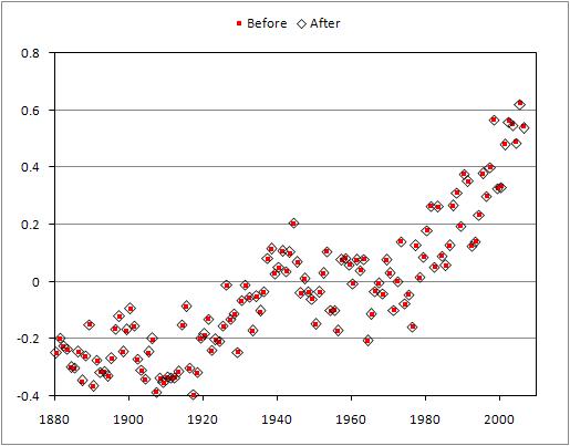
What I do want to point out is that Tamino over at Open Mind has yet again boiled all the hub-bub down to its essence (by the way, Open Mind one of the best climate science blogs out there). Please follow that comment thread if you want to get into the nitty gritty.

Here, he plots the temperature data before the correction (in red squares) with the now corrected data (open diamonds).


Alrighty then.

------------------------------

UPDATE: This is just too good to not mention. I'm not sure why I did it....maybe I was bored, but I went onto the blog I mention above (the numskulls) and got into some back-and-forth commenting. I was being civil (at least compared to the tone of the rest of the commenters), and I simply pointed them to Tamino's graph and asked them why the error and its correction is proof that global warming theory is all of the sudden invalid. I got a response that didn't address the data or my question; it was a ranting non sequitur (and I even tried to pre-emptively discourage non sequiturs to focus the discussion). Then I was called a "leftist". Good argument. And then, finally, the blog owner removed my comments. If you go down to the comments numbered in the mid 80s or so, you'll see my comments clipped with a snarky response, but the actual full comment was removed. But, I just hit refresh and some other comments were further manipulated....so, who knows.

People can do whatever the hell they want on their blogs. But, if you say this...

Comments are welcome, even those that contradict the main post. However, comments may be deleted for profanity, racism, threats, harassment, spam, or if they are deemed inappropriate.
...and then delete them anyway, you're completely misrepresenting yourself. I guess my comments were deemed "inappropriate" because they challenged their narrow-minded view. Plus, i'm sure the blog owner didn't want that pesky link to a graph for his followers to see....they might be educated and leave his blog. Go on over to this post at Deltoid to see "The Ace" in action (starting around comment #110 or so)....very entertaining!


--------------------------
*I've said it before, and i'll say it again. The mixture of the evidence for warming, attribution, and policy in this global discussion is unfortunate. I do think that the real debate to be having now is what should we do and how should we do it (i.e., policy). But, the denialists continue to muddle that serious debate with nonsense about the scientific basis, claims of conspiracy, or simply their hatred for Al Gore. When having discussions with people I always try and "tag" each aspect into (1) data; the measurements, (2) attribution; the cause, and (3) policy; what to do about it. I found this clears up the mud significantly in serious discussions and causes nonsensical and emotional partisan arguments to be revealed rather quickly.

Saturday, August 11, 2007

So What

It's been too long since I had a post about music. If you like jazz, you'll love this rendition of trumpeter Miles Davis' "So What" featuring John Coltrane on saxophone from 1958.

I especially like how these cats hang around in the background just chillin' during Coltrane's solo. Good stuff.

Friday, August 10, 2007

Friday Field Foto #25: Ancient organic detritus

Many modern river delta environments are chock full of organic matter (think Louisiana swamp). Much of it is plant and other woody material. In some cases, this material is buried and remnants or evidence of it are preserved when the sediment lithifies.


The photos above show the bedding plane view (looking down on top of the surface of sedimentary layer) of a deposit rich with organic detritus (i.e., pieces of stuff). A lot of it is preserved woody fragments. Also note the dark black flecks...this material is mostly carbonaceous shale, which is kind of like coal. Click on these to see the high-res versions.

The organic detritus is abundant in thin (~1 cm) layers. The photo below is a cross-sectional view where you can see the layering of the sedimentary rock. The darkest layers (the pencil is pointing to one) are dark in color because they are full of this organic detritus and coaly bits.


But, wait, these are turbidites? It says so in the post label. How can you have all this terrestrial organic matter on the deep sea floor? In this case, this turbidite system is being fed by a delta. In the upper photographs, notice how broken up all the organic matter is. It has been ripped up and flushed off the delta environment and into the deep sea, where it was likely buried rather quickly. We find abundant organic detritus on the very tops of turbidite beds....this material is relatively light compared to the medium-grained sand and, therefore, is deposited after the sand as the flow slows down (ending up on top).

The organic detritus-rich nature is, in fact, one of many lines of evidence telling us that these Cretaceous strata are delta-fed turbidite deposits.

Thursday, August 09, 2007

On the nonlinearity of drafting a manuscript

Do you write papers in a neat, orderly fashion? Kind of like they taught you back in grade school -- with the outline first, and then you go write each section and subsections?

I sure as hell don't.

I've been writing up another big chunk of my dissertation work lately (you'll notice my posting frequency has increased too....hmmm). I find it hard to stay in one section of the paper for more than 10-15 minutes. While working on the Introduction, I think of something I need to discuss in the....well, in the Discussion, so I type a few reminder phrases as a place marker. As I scroll back up to the Introduction I remember that I forgot to look up the number that goes where the highlighted red "X" is. That's right, I need to address that aspect in the Introduction so when I reveal my data later it all fits together nicely....yes, that'll be awesome! But, oh crap....now i'm opening a spreadsheet. Oh crap....I found a seemingly small, but cascading error in one of the tables. Did I really do that wrong? That was stupid. How bad is it?

Instead of dealing with it right away, I decide to go back to the text and finish my train of thought. What train of thought?


cartoon above from here

Nanobots controlling your consciousness

If you haven't been to the TED website yet...do it. TED is an annual conference held in Monterey, CA designed to share ideas. Speakers included scientists, economists, sociologists, artists, and many others. Their website hosts the videos for these ~20-minute talks from meetings over the last five years or so.

The "T" in TED is for technology.
This talk is by Ray Kurzweil, who is best described as a futurist. His ideas about the acceleration of technology are controversial but incredibly interesting. Even if what he talks about doesn't actually happen, I think having the conversation in the first place is valuable.

Here's the description blurb from the TED website:

Prolific inventor and outrageous visionary Ray Kurzweil explains in abundant, grounded detail why -- by the 2020s -- we will have reverse-engineered the human brain, and nanobots will be operating your consciousness. Kurzweil draws on years of research to show the speed at which technology is evolving, and projects forward into an almost unthinkable future to outline the ways we'll use technology to augment our own capabilities, forever blurring the lines between human and machine.
I've embedded the video below...or click here to watch it on TED site.


I've read Kurzweil's latest book, called The Singularity is Near, which I mean to write a review of at some point. This talk is a very condensed version of the ideas he puts forth in his book.

Wednesday, August 08, 2007

Visual relation-based search engine for books

It seems more and more when I am looking for a book or a review of a book I end up on a page that links to Amazon. I can't remember exactly how I found this site (amaznode), but it's a way to search through Amazon's catalog visually.

The way it works is that it connects books through the 'customers who bought this also bought this' data. It's kind of interesting.
For example, in the screenshot image above I put in 'Patagonia geology' into the search box and the book cover thumbnail images started popping up. Another moment later, connections denoted by lines were drawn. This image is a snapshot in the process...it kept going until it filled in the entire Amazon catalog that satisfied the search terms.

The main group of books near the top are a bunch of travel and trekking books. The group to the right is a bunch of Patagonia fly fishing books, and the third major group near the bottom of the image represents a group of South American cookbooks. I'm not sure where the geology search term comes in here....hmmm.

And then you can move your cursor over the thumbnail and the book title pops up. If you click on it, a little box pops up from which you can go to the regular Amazon page or say 'put in cart' and keep going.

This style of searching and the visual revealing of links is becoming more abundant on the web. I'm not sure it's robust enough (yet) to replace any searching methods, but it is an interesting additional way to find things. Especially, when you are curious about how the different books are linked. I would guess those researching marketing trends might find this very interesting.

It's fun. Try it.

Blog devoted to extrasolar planets

You may have seen the news earlier this week about another discovery of a planet outside our solar system. These discoveries are coming fast and furious these days...it is exciting.

Are you feeling a little unsatisfied after reading the press releases and mainstream news articles? Are you yearning for more information?
Check out the blog Systemic, which is devoted to extrasolar planetary systems. And they don't just post about the latest news, but also are engaged in collaborative research:

The near-term goal of the systemic research collaboration is to improve our statistical understanding of the galactic planetary census. This will be accomplished through a large-scale simulation in which the public is invited to participate. No prior experience or expertise with Astronomy is required. All you need is an Internet connection and a desire to learn and explore.
Not only is Systemic informative, but it is beautifully designed.
Check it out.

Tuesday, August 07, 2007

United States federal funding of science

Check out a news brief just released by the AAAS regarding the federal (United States) spending on scientific research proposed for the 2008 budget.


As of the August congressional recess, Congress is poised to add billions of dollars to proposed budgets for the federal investment in research and development (R&D) for fiscal year (FY) 2008. The House and Senate would endorse large proposed increases for select physical sciences agencies in the President’s American Competitiveness Initiative (ACI) and would continue to support Administration plans to expand development investments for new human spacecraft. But instead of cutting funding for other R&D programs as requested, the House and the Senate would provide increases to every major nondefense R&D funding agency, and would turn proposed cuts into significant increases for the congressional priorities of biomedical research, environmental research (particularly climate change research), and energy R&D. The added billions in FY 2008 appropriations so far would turn a requested cut in federal support of basic and applied research into a real increase, after three years of decline.

Could this be some good news? Maybe so, maybe not...
But these increases depend on an overall congressional budget plan allocating $21 billion more for domestic appropriations than the President’s budget; because the President has threatened to veto any appropriations bills that exceed his budget request, these R&D increases could disappear or diminish this fall in negotiations between the President and Congress over final funding levels

Feel free to let your doubt, cynicism, frustration, or optimism (!?) flourish in the comments below.

Monday, August 06, 2007

The Quantum Cheneyverse

Good stuff....click on cartoon to go to source.

More submarine territoriality

My previous post dealt with Russia's claim of that the Arctic's Lomonosov Ridge belongs to them since it once was part of the Siberian continental shelf. It seems Argentina may have some issues about what part of the submarine landscape is theirs as well. Check out this short article from IPS (via geology.com). I don't have the time right now to dig into this one in any detail, but here's a blurb:

To draw up a definitive proposal for its maritime border, in 1997 Argentina created the National Commission of the Continental Platform Exterior Limit (COPLA), an inter-ministerial technical team that reportedly has already gathered 90 percent of the information necessary to demonstrate exactly where its territory covered by the ocean comes to an end.

Countries with ocean coasts have sovereign rights over the sea bed and subsoil to 200 nautical miles from land, which is known as the exclusive economic zone, or to where its continental platform ends, including the slope, up to a maximum of 350 miles. That includes the platform's natural resou
rces, but not the water that covers it.

The data obtained in laboratories and sea missions will have to be presented before May 2009 to the Commission on Continental Platform Boundaries, a technical body of the United Nations Convention on the Law of the Sea, which will decide whether to authorise the new border demarcation.
Unfortunately, this article does not show a map of the area in question (wouldn't the citizens of this globe be so much more knowledgeable of geography if maps were always included?! .... but I digress).

Below is a map showing the topography and bathymetry of southern South America. The Argentine continental margin is a very different geologic situation than the one I discussed in the last post. This is a passive margin with a relatively wide continental shelf.

Argentina may have a better argument than Russia on this one. At least the shelf is still attached to the continent here.


If anyone, especially anyone reading this from South America, knows any more details about this, please don't hesitate to post a comment.

Click on the image to go to the source.

Sunday, August 05, 2007

Geology, geopolitics, and the Law of the Sea

In the international game of territorial rights, geology matters.

Russia made news last week with their largely symbolic flag-planting on the Arctic sea floor at the north pole. The Arctic region is thought to host significant amounts of petroleum resources and, as the world's demand for oil continues to grow combined with the disappearance of sea ice, nations wish to claim as much of this real estate as they can before exploration operations begin.

There is plenty of commentary out there on the blogs about this story specifically and the notion of Arctic oil exploration in general (e.g., here, here, and here) so I'm not going to focus on that. When I came across the short news article in this week's Nature, I became more interested in what criteria are used to decide which nation gets what when it comes to the sea floor.

The Nature article is here, you'll have to have a full license to see the whole thing, but I will quote a bit of it below.

The 1982 United Nations Convention on the Law of the Sea (UNCLOS) allows states an economic zone that extends 200 nautical miles from their coastline. To increase this, countries must prove to the United Nations Commission on the Limits of the Continental Shelf that their physical continental margin extends farther than this.
The map from the Nature article (right) shows the 200 nautical mile line as a blue dotted line. Russia thinks they deserve more. They are claiming the Lomonosov Ridge is an extension of their continental shelf, which would significantly extend their sea floor territory.
If Moscow can prove that the structure of the continental shelf under the ocean is geologically similar to that of Russian land, it may be able to extend its territory. The Lomonosov Ridge, which it sees as a continental extension, is key to its claims. Russia hopes to claim 1.2 million square kilometres and, with it, the rights to copious mineral and fossil-fuel reserves.
Check out the full UN Convention on the Law of the Sea treaty here. If you go to the section on the continental shelf, you'll find this statement as part of the definition:
The continental margin comprises the submerged prolongation of the land mass of the coastal State, and consists of the seabed and subsoil of the shelf, the slope and the rise. It does not include the deep ocean floor with its oceanic ridges or the subsoil thereof.
Emphasis mine. My first impression is that the Lomonosov Ridge, being an oceanic ridge and all, should therefore not be part of the definition of a states continental shelf territory. If a state disagrees with this determination, then they need to formally contest it with this UN entity, which they did, according to the Nature article:
In 2001, Russia became the first country to make a submission to the United Nations. It was told to supply more information, in particular about the Lomonosov Ridge, which runs under the Arctic Ocean between Russia and Canada. Russia claims this ridge is an extension of its Siberian shelf, but this is hotly contested by Canada and others.
What is the Lomonosov Ridge? I'm not an expert on Arctic geology, so I welcome any comments or links to better sources (especially resources in Russian). A quick search uncovered a 1992 Geology paper by Jokat et al.:
The 1500-km-long and 50-70-km-wide ridge rises 3 km above the adjacent abyssal plains and divides the Arctic Ocean into the Eurasian and Amerasian basins.

The ridge is postulated to be a continental fragment severed from the margin during the early Cenozoic opening of the Eurasian basin.
The Jokat et al. paper makes some conclusions about the origins of the ridge based on multichannel seismic-reflection data they acquired:
The geometry and attitude of the deposits below the ridge unconformity strongly suggest the Lomonosov Ridge is the remnant of a prograding continental shelf facing the Makarov Basin.

The progaded ridge flank facing the Makarov Basin indicates an early history of slope-rise sedimentation into the basin that existed before the Lo
monosov Ridge separated from Eurasia.
On the map at the top of the post, the Makarov Basin is the region shaded in orange above where it says Lomonosov. Assuming these conclusions are correct, then Russia's (and maybe Norway's little section) paleo continental shelf did include what is now the oceanic ridge. But, of course, the determination is on the present configuration, right? Well, Russia is indeed claiming that since the ridge originated as part of the Siberian shelf, then it is still theirs.

Talk about opening a can of worms. Imagine if the UN allowed arguments of current territorial boundaries to be determined by where the territory was 10s of millions of years ago! That would get interesting.

How will all of this affect scientific research in the Arctic? I think it's a double-edged sword in many ways. The prospects of opening the region to resource development will create major problems for researchers getting access to certain areas. On the flip side, a lot of mapping and imaging of the sea floor needs to be done to figure all of this out. The UN has said that their is "insufficient data" to resolve this. I'm certainly hesitant to be gung-ho about opening the relatively pristine Arctic region to petroleum operations, but, at the same time I get excited about the prospects of increasing our overall understanding of that region through sea-floor mapping, which is very expensive.

It will be interesting to see how this all shakes out.
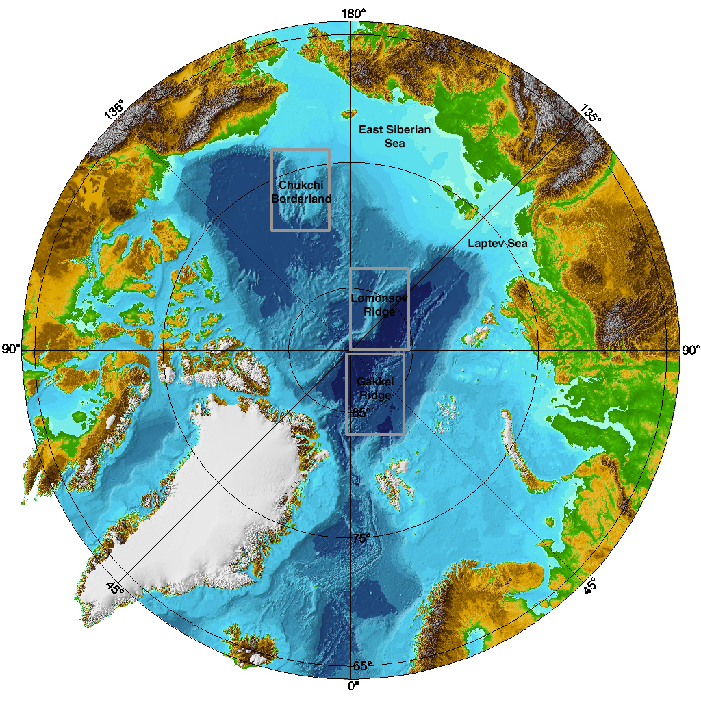
Get more information about the map above here.

Note: this post cross-posted on August 8th, 2007 edition of www.geology.com/news
Additional information on Lomonosov Ridge from Olelog here.


Cold War Goes North; Kommersant

Wikipedia's page on the Lomonosov Ridge, which has a nice collection of links related to Russia's territorial claim.

W. Jokat, G. Uenzelmann-Neben, Y. Kristoffersen, and T.M. Rasmuessen, 1992, Lomonosov Ridge; a double-sided continental margin: Geology, 20(10):887-890

Saturday, August 04, 2007

Take the ...Or Something poll

Blogger has added poll capability now, so I decided to give it a shot. Even though they say these polls are unscientific, what if the question is about science? Yeah....that's right.

Anyway, my readership is not huge (yet) but is growing. My guess has always been its mostly my fellow geoblogospherons and a smattering of others that find themselves here. I'm curious to see what y'all are doing these days....so, take the poll (top of sidebar to the right).

Of course, the risk with these polls is that it effectively proclaims to the world just how lame your blog is because you have two votes on it for about a week. That's why it'll be open for several days.

I've accepted and even embraced my lameness a long time ago.

Video of experimental turbidity current

I post about turbidites a lot on this blog. I have never included a link to an online explanation of them because I am simply not satisfied with them. I should create a post of my own to do this but....well, that's a lot of work and I don't want to do it half-ass....you all know how it is.

If you have no idea what a turbidite is....then check out the Wikipedia turbidite page. It's only okay...some of it is not quite right and there's a severe lack of external links.

Like many geoscientists, I find that visuals help immensely in understanding processes. We can go to a modern river, delta, tidal inlet, etc. and observe firsthand the processes. We cannot do this in the deep water; our monitoring of processes in this environment is extremely limited and still more-or-less indirect.

This is where lab experiments have value. But, turbidity currents that have been observed in historical times can be huge. The earthquake-triggered turbidity current that occurred offshore of eastern Canada in 1929 is estimated to have been 400 m tall, lasted for at least 12 hours, and traveled hundreds of km into the abyssal plain (note: I will post about that story another time...it is really cool). So, we have to scale them down. There are problems with assuming scale-independence when it comes to sedimentary processes, but, as a general exercise, we have learned a great deal from experiments.

This video below (via Paul Heller's website) shows an experimental turbidity current in a tank. It is kind of long (>3 min)....you'll get the idea after 30 seconds or so. Remember, this is subaqueous...notice the "head" of the current plowing its way through the water. The ambient fluid does not get incorporated into the current at the head, but rather is displaced over the top and mixes with the more dilute cloud. In this way, the turbidity current grows over time. The head also travels faster than parts of the flow behind it, which results in a lengthening of the current over time and distance. If you do watch the video to the end, you'll get an appreciation of how real turbidity currents can last so long....it simply takes a long time for them to come to rest. The more volume, the longer the duration.


Stay tuned for more posts about the fundamental processes of turbidity currents and the deposits they create.

Friday, August 03, 2007

High-resolution sea-floor image offshore San Diego

Just a quick post today to show you one of the latest multibeam bathymetric images released by the US Geological Survey. Go to this page to view and download the large-format PDFs.

If you'd like to know more about the technical details of the concept, design, and acquisition of multibeam sonar data, check out resources here and here.

This one is definitely worth clicking on to see the high-res version. The densely populated onshore area to the right is San Diego, California. For a more regional context of southern California geologic provinces, check out this page. The San Andreas fault is 10s of km inland from this location, but subsidiary strike-slip faults dominate the tectonic fabric.

The major submarine canyon cutting into the narrow continental shelf is called La Jolla Canyon. The head of that canyon comes very close to the pier at Scripps Institute of Oceanography if any of you have been there. Note the transition from the deeply incised submarine canyon to a submarine channel system as you go into deeper water. Also note the meandering nature of the individual channel "threads" within the belt. This submarine channel eventually empties into the elongate San Diego Trough basin, which is off the image to the left and in even deeper water.

A paper that i'm a co-author on is coming out in Geology next month and deals with this canyon-channel system in more detail and its history over the last 40,000 years. I will post about that soon, so stay tuned.

The USGS page also has some great perspective views....here is the link again, check it out.

Wednesday, August 01, 2007

Conglomeratic intrusions

Okay....this is another long post....maybe too long, but oh well.

A former fellow student (now professor), me, and our adviser have a paper out this month characterizing some very unique sedimentary features in Cretaceous strata of southern Chile: conglomeratic injectites.
Clastic intrusions, now termed injectites, have been recognized for a long time. In some cases, they resemble igneous intrusions (dikes, sills, etc.) with respect to their geometric relationship to the surrounding rock.

What are injectites?

They represent the violent remobilization of typically coarse sediment like sand due to over-pressurization. The best visual I can give you is imagine that you could press down on a jelly donut that was somehow sealed along the sides. That is, the jelly does not squeeze out of the side when you put pressure on it from above (overburden). Now imagine some plane of weakness in the fabric of the donut above the jelly layer. The overburden pressure will force the jelly into that plane of weakness and upward. If the movement of the jelly is of sufficient magnitude it will bust its way through the donut, creating its own path, and perhaps erupting at the surface of the donut.

Coarse sediment (usually sand) that is deposited in deep-marine settings is a mixture of sediment and water and it takes a while for the deposit to slowly de-water. If the sediment accumulation rate is high enough -- that is, if these water-laden deposits get buried relatively quickly by more sediment this layer becomes the "jelly". The increasing overburden pressure combined with some sort of trigger (seismicity? a threshold?) creates a situation for this large-scale injection to occur.

What's cool about our study (at least we think its cool) is that we have (1) a great outcrop example of this phenomenon where the features are explicitly exposed and (2) the injected material is very coarse -- cobble-sized material.

Now, we'll be the first to admit that this paper is not high science. We literally came across these features and spent a few days mapping them out and characterizing them. There's only so much time in a field season and we had other tasks to accomplish. So, this paper is very descriptive in that way...that is, we did not take it to the level of really figuring out how these things work. The mechanics of clastic injection is not well understood.

Because injectites are associated with thick piles of sediment they are being found by oil companies exploring for hydrocarbons in the subsurface. In fact, one hypothesized mechanism for contributing to over-pressurization is gas charging. Believe it or not, there is an entire book about the occurrence of clastic injectites and their relationship to petroleum systems. This paper is in that book. We were happy that the editors really wanted this stuff in there since we weren't sure where else it would ever get published. Take it when you can get it!


Okay...enough set up....here we go.

The figure above is the location information. I've said in the past that I would put together a post about the general geology of the area i've been working in Patagonia....I still mean to do that....someday. As always, click on the image to get a higher resolution view. The study area, Cerro Benitez, is in the center of the satellite image at right. These Cretaceous strata are part of the Magallanes foreland basin and now nicely exposed in the foothills of the southernmost Andes.

The photos above show some of the close-up characteristics of these conglomeratic deposits. Notable are the near vertical groove-like features in F and G. By themselves, however, these small-scale features are not very telling.


This next set of photographs (above) takes a step back and shows the conglomerate bodies in their full glory. The one shown in A and then enlarged in B is particularly nice (note circled person [me] for scale in each). When we first came across these features we thought the juxtaposition of the conglomerate against the shale had to be a fault contact. It's not...we mapped the entire area. Then we thought these were some kind of channelized deposits, but the geometries were just not working out. When we spent a few days mapping out the multiple bodies and their relationship, an interesting picture emerged.


The last day of characterizing the injection complex, we hiked to the other side of the lake and climbed up a mountain to take the photograph above. We felt we needed a view zoomed out even more....it took a day to get this photo....not the first time we spent a day to get a photograph down there. In the corresponding drawing below the photo, the yellow is the "regular" conglomerate bodies (referred to as stratified conglomerate) and the dark brown denotes the injected conglomerate. The cool part about this outcrop is that the old glacial lake created a flat terrace (shown in lighter gray) between two more vertical slices of the stratigraphy (shown in the dark gray). So, it's sort of a "chair" display if you can visualize it. This little bit of three-dimensionality helped immensely in mapping out the different bodies.


The schematic cartoon above (or, as the first author Steve likes to call it, the geophantasmogram) attempts to summarize the outcrop and how we've mapped it. Again, note the "chair" set up. The injectites emanate from the side of the channel-fill deposits, which is a pattern seen in injectites in the subsurface over and over again. Also, note the left complex on the diagram bifurcate and then head up through the strata until they terminate. The photos above with me for scale is the right branch of that bifurcating complex. The very ends of those injectite bodies lack conglomerate and are instead only sand reflecting a "fining-away" trend. That is, the "flow" of material had to come to a stop at some point, and the brief slowing down before stopping was enough to sort the material being carried.


The last thing I want to touch on is the scale of this injectite complex compared to other known and well-studied examples from the subsurface. The figure above (which is the bottom half of the geophantasmogram) shows the cross-sectional outline of the injectite complex we characterized with some that have been mapped using seismic-reflection data in the North Sea. Firstly, notice the "winged" appearance of nearly all of these examples. Secondly, the bottom line is -- our complex, as big as it seemed, is a tiny little sucker. For example, note the small rectangle on one of the little nubs in D. That rectangle represents the size of the complex we characterized. These North Sea injectite complexes are friggin' HUGE! It kind of blows my mind.
Anyway, i'm gonna cut myself off....this post is already ridiculously long. If you'd like to know more about the nitty gritty, please feel free to comment below or e-mail me at romansbrian AT gmail.