Showing posts with label turbidites. Show all posts

Wednesday, August 22, 2007

Paper out in Geology

THIS POST CAN BE FOUND AT NEW BLOG, CALLED CLASTIC DETRITUS, HERE

A paper i'm a co-author on is in the September edition of Geology. I'm swamped right now and don't have time to write a coherent post about it....but I will soon.

In the meantime, check it out (if you have access, of course):

Highstand fans in the California borderland: The overlooked deep-water depositional systems
Jacob A. Covault, William R. Normark, Brian W. Romans, and Stephan A. Graham


Friday, August 10, 2007

Friday Field Foto #25: Ancient organic detritus

Many modern river delta environments are chock full of organic matter (think Louisiana swamp). Much of it is plant and other woody material. In some cases, this material is buried and remnants or evidence of it are preserved when the sediment lithifies.


The photos above show the bedding plane view (looking down on top of the surface of sedimentary layer) of a deposit rich with organic detritus (i.e., pieces of stuff). A lot of it is preserved woody fragments. Also note the dark black flecks...this material is mostly carbonaceous shale, which is kind of like coal. Click on these to see the high-res versions.

The organic detritus is abundant in thin (~1 cm) layers. The photo below is a cross-sectional view where you can see the layering of the sedimentary rock. The darkest layers (the pencil is pointing to one) are dark in color because they are full of this organic detritus and coaly bits.


But, wait, these are turbidites? It says so in the post label. How can you have all this terrestrial organic matter on the deep sea floor? In this case, this turbidite system is being fed by a delta. In the upper photographs, notice how broken up all the organic matter is. It has been ripped up and flushed off the delta environment and into the deep sea, where it was likely buried rather quickly. We find abundant organic detritus on the very tops of turbidite beds....this material is relatively light compared to the medium-grained sand and, therefore, is deposited after the sand as the flow slows down (ending up on top).

The organic detritus-rich nature is, in fact, one of many lines of evidence telling us that these Cretaceous strata are delta-fed turbidite deposits.

Saturday, August 04, 2007

Video of experimental turbidity current

I post about turbidites a lot on this blog. I have never included a link to an online explanation of them because I am simply not satisfied with them. I should create a post of my own to do this but....well, that's a lot of work and I don't want to do it half-ass....you all know how it is.

If you have no idea what a turbidite is....then check out the Wikipedia turbidite page. It's only okay...some of it is not quite right and there's a severe lack of external links.

Like many geoscientists, I find that visuals help immensely in understanding processes. We can go to a modern river, delta, tidal inlet, etc. and observe firsthand the processes. We cannot do this in the deep water; our monitoring of processes in this environment is extremely limited and still more-or-less indirect.

This is where lab experiments have value. But, turbidity currents that have been observed in historical times can be huge. The earthquake-triggered turbidity current that occurred offshore of eastern Canada in 1929 is estimated to have been 400 m tall, lasted for at least 12 hours, and traveled hundreds of km into the abyssal plain (note: I will post about that story another time...it is really cool). So, we have to scale them down. There are problems with assuming scale-independence when it comes to sedimentary processes, but, as a general exercise, we have learned a great deal from experiments.

This video below (via Paul Heller's website) shows an experimental turbidity current in a tank. It is kind of long (>3 min)....you'll get the idea after 30 seconds or so. Remember, this is subaqueous...notice the "head" of the current plowing its way through the water. The ambient fluid does not get incorporated into the current at the head, but rather is displaced over the top and mixes with the more dilute cloud. In this way, the turbidity current grows over time. The head also travels faster than parts of the flow behind it, which results in a lengthening of the current over time and distance. If you do watch the video to the end, you'll get an appreciation of how real turbidity currents can last so long....it simply takes a long time for them to come to rest. The more volume, the longer the duration.


Stay tuned for more posts about the fundamental processes of turbidity currents and the deposits they create.

Wednesday, August 01, 2007

Conglomeratic intrusions

Okay....this is another long post....maybe too long, but oh well.

A former fellow student (now professor), me, and our adviser have a paper out this month characterizing some very unique sedimentary features in Cretaceous strata of southern Chile: conglomeratic injectites.
Clastic intrusions, now termed injectites, have been recognized for a long time. In some cases, they resemble igneous intrusions (dikes, sills, etc.) with respect to their geometric relationship to the surrounding rock.

What are injectites?

They represent the violent remobilization of typically coarse sediment like sand due to over-pressurization. The best visual I can give you is imagine that you could press down on a jelly donut that was somehow sealed along the sides. That is, the jelly does not squeeze out of the side when you put pressure on it from above (overburden). Now imagine some plane of weakness in the fabric of the donut above the jelly layer. The overburden pressure will force the jelly into that plane of weakness and upward. If the movement of the jelly is of sufficient magnitude it will bust its way through the donut, creating its own path, and perhaps erupting at the surface of the donut.

Coarse sediment (usually sand) that is deposited in deep-marine settings is a mixture of sediment and water and it takes a while for the deposit to slowly de-water. If the sediment accumulation rate is high enough -- that is, if these water-laden deposits get buried relatively quickly by more sediment this layer becomes the "jelly". The increasing overburden pressure combined with some sort of trigger (seismicity? a threshold?) creates a situation for this large-scale injection to occur.

What's cool about our study (at least we think its cool) is that we have (1) a great outcrop example of this phenomenon where the features are explicitly exposed and (2) the injected material is very coarse -- cobble-sized material.

Now, we'll be the first to admit that this paper is not high science. We literally came across these features and spent a few days mapping them out and characterizing them. There's only so much time in a field season and we had other tasks to accomplish. So, this paper is very descriptive in that way...that is, we did not take it to the level of really figuring out how these things work. The mechanics of clastic injection is not well understood.

Because injectites are associated with thick piles of sediment they are being found by oil companies exploring for hydrocarbons in the subsurface. In fact, one hypothesized mechanism for contributing to over-pressurization is gas charging. Believe it or not, there is an entire book about the occurrence of clastic injectites and their relationship to petroleum systems. This paper is in that book. We were happy that the editors really wanted this stuff in there since we weren't sure where else it would ever get published. Take it when you can get it!


Okay...enough set up....here we go.

The figure above is the location information. I've said in the past that I would put together a post about the general geology of the area i've been working in Patagonia....I still mean to do that....someday. As always, click on the image to get a higher resolution view. The study area, Cerro Benitez, is in the center of the satellite image at right. These Cretaceous strata are part of the Magallanes foreland basin and now nicely exposed in the foothills of the southernmost Andes.

The photos above show some of the close-up characteristics of these conglomeratic deposits. Notable are the near vertical groove-like features in F and G. By themselves, however, these small-scale features are not very telling.


This next set of photographs (above) takes a step back and shows the conglomerate bodies in their full glory. The one shown in A and then enlarged in B is particularly nice (note circled person [me] for scale in each). When we first came across these features we thought the juxtaposition of the conglomerate against the shale had to be a fault contact. It's not...we mapped the entire area. Then we thought these were some kind of channelized deposits, but the geometries were just not working out. When we spent a few days mapping out the multiple bodies and their relationship, an interesting picture emerged.


The last day of characterizing the injection complex, we hiked to the other side of the lake and climbed up a mountain to take the photograph above. We felt we needed a view zoomed out even more....it took a day to get this photo....not the first time we spent a day to get a photograph down there. In the corresponding drawing below the photo, the yellow is the "regular" conglomerate bodies (referred to as stratified conglomerate) and the dark brown denotes the injected conglomerate. The cool part about this outcrop is that the old glacial lake created a flat terrace (shown in lighter gray) between two more vertical slices of the stratigraphy (shown in the dark gray). So, it's sort of a "chair" display if you can visualize it. This little bit of three-dimensionality helped immensely in mapping out the different bodies.


The schematic cartoon above (or, as the first author Steve likes to call it, the geophantasmogram) attempts to summarize the outcrop and how we've mapped it. Again, note the "chair" set up. The injectites emanate from the side of the channel-fill deposits, which is a pattern seen in injectites in the subsurface over and over again. Also, note the left complex on the diagram bifurcate and then head up through the strata until they terminate. The photos above with me for scale is the right branch of that bifurcating complex. The very ends of those injectite bodies lack conglomerate and are instead only sand reflecting a "fining-away" trend. That is, the "flow" of material had to come to a stop at some point, and the brief slowing down before stopping was enough to sort the material being carried.


The last thing I want to touch on is the scale of this injectite complex compared to other known and well-studied examples from the subsurface. The figure above (which is the bottom half of the geophantasmogram) shows the cross-sectional outline of the injectite complex we characterized with some that have been mapped using seismic-reflection data in the North Sea. Firstly, notice the "winged" appearance of nearly all of these examples. Secondly, the bottom line is -- our complex, as big as it seemed, is a tiny little sucker. For example, note the small rectangle on one of the little nubs in D. That rectangle represents the size of the complex we characterized. These North Sea injectite complexes are friggin' HUGE! It kind of blows my mind.
Anyway, i'm gonna cut myself off....this post is already ridiculously long. If you'd like to know more about the nitty gritty, please feel free to comment below or e-mail me at romansbrian AT gmail.


Friday, July 27, 2007

Friday Field Foto #24: Conglomerate injectites

I don't have a lot of time right now...still traveling...but wanted to get this Friday Field Foto posted while I wait for my flight (hopefully a better experience than the trip here). I'm not traveling at all for the next 5 weeks, so I should be blogging more frequently (and finishing my dissertation).

A paper I'm a co-author on just came out, which I will post about in more detail next week. The photo above (that's me for scale) is a great view of some conglomerate injectites in Cretaceous sedimentary rocks down in Patagonia. I showed a photo of some smaller injectites previously on this blog.

Note the flat lying shale and thin-bedded sandstone that I am standing on juxstaposed against a more resistant conglomeratic body that is nearly vertical.

That must be a fault, right? Wrong. I know this may sound crazy, but this feature represents the upward injection of coarse-grained material through the overlying deposits. Yeah....right. Give me a few days and I'll put together a better explanation of all this. It's pretty wild stuff.

Friday, July 13, 2007

Friday Field Foto #23: Flame structures


Today, we have another sedimentary structure commonly seen in turbidite successions. The features above that look like flames are called.......drum roll........ flame structures (brilliant!). Right in the center of the photograph notice the slightly darker and curved lines in the rock. They meet upwards at a tip and are pointing to the right.

Flame structures form as the upper part sinks into the underlying sediment, often referred to as 'loading'. This loading commonly occurs in localized pods and then the sediment in between gets squeezed up a bit. The directional component of this (the tip of the 'flame') is produced because there is still some current strength which shears the material just slightly before everything comes to rest as a deposit. So, in the case above the local current direction was left to right.

How does loading occur in the first place?
Firstly, the underlying bed cannot be completely dewatered. That is, it is still a mixture of sediment and water is likely in a 'soupy' state. Secondly, there needs to be a density contrast. The overlying material has to sink into the soupy bed to be able to displace the material like this. You may have seen flame structures before where coarser material (usually sand) sinks into much finer-grained material. But, in this case all the material is sand of similar grain size. The density contrast is set up because the overlying sediment has much more water in it still. Remember, sediment gravity flows are a mixture of sediment in suspension and water....this is very different than fluid flows where the sand is transported as bedload.

So, what does this tell us?
In this case, if you were to examine this deposit laterally away from where this photo was taken the loading and flame structures disappear and the bed is completely homogeneous. This is just a localized structure within a bed and not a boundary between discrete events. Turbidity currents commonly exhibit 'surging' behavior. As the flow moves down-slope it will begin to separate into multiple sub-flows. Or so we think....our knowledge of how these things actually work is incredibly limited.

Friday, July 06, 2007

Friday Field Foto #22: Rip-up clasts

More turbidites!

I'm actually going to visit these rocks early next week for a couple days. This is north of the Bay Area near the charming little coastal town of Gualala (which is fun to say out loud).

In this photo (note coin for scale) we see a complex mixture of pebbly sandstone (near bottom), coarse sandstone, and siltstone and mudstone (darker-colored rock). Note how the coarse sandstone seems to surround the large area of dark mudstone. The mudstone areas are actually clasts within a thick (>5 m) sandy turbidite bed. We call these "rip-up clasts" as they were deposits on the sea floor that were ripped up by a subsequent turbidity current, incorporated into the flow as a clast, and eventually deposited. Muddy material can be quite cohesive and can stay together as a coherent clast like this. Think about making a mudball vs. a sandball with your hands. The sand disaggregates much easier.

As mudstone rip-up clasts go, these are probably slightly above average in size. We commonly see smaller (centimeter scale) and once in a while you'll see a deposit with larger rip-up clasts.

Friday, June 15, 2007

Friday Field Foto #21: Climbing ripples

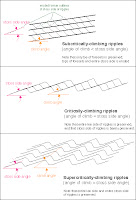
Today we are gonna look at some ripple cross-laminated sandstone. More specifically these are called 'climbing ripples', or sometimes you may see this sedimentary structure referred to as 'ripple drift'. These show up particularly nice in this photo because of the light-dark contrast of the sandy vs. muddy laminae.

Climbing ripples record both migration (lateral) and aggradation (vertical) of the bedform. In this example note the very prominent ripple set in the middle section of the photo nicely showing the 'climb' from left to right. Different angles of climb represent different ratios of migration and aggradation. Climbing ripples are commonly interbedded with or grade upwards into wavy laminae.


This image at left is a classification of types of climbing ripple-laminated structures based on the angle of climb (click on image for larger view; click here for source of image).

Climbing ripples are most commonly seen in river and turbidity current deposits, typically in sub-environments of high rates of deposition from decelerating flows.


On a side note, Dr. Lemming has pointed out a new geology-related blog out there. It's called All of My Faults Are Stress Related and looks to be a nice addition to the geoblogosphere. I have a few more new links over there on the sidebar that i'll post about soon.

I also have an updated album of Patagonia photos you can check out here. The above image is from that collection.

Friday, May 11, 2007

Friday Field Foto #16: Sand injectites

Okay, back to Patagonia for this week's photo.


This isn't in my specific field area, but very close to it and in the same formation. What's really cool about this area is the presence of clastic dikes....or, what have now been termed "injectites", as in the injection of sand. In this photo you'll notice the light-colored streaks cutting up and to the right across the flat-lying strata. These features are sandstone.

Injectites have been recognized for over a hundred years, but have been more appreciated in recent years. Oil companies searching for petroleum in the North Sea have seen huge networks and complexes of injectites with seismic-reflection data. And I mean huge...some of the individual sandstone "dikes" can be kilometers long cutting sub-vertically through the strata.

In the case above, the orientation of this swarm of injectites are parallel to a growth fault (i.e., syn-depositional) lower in the section.

There is still much debate about the mechanics of these things...what kinds of overpressures are required, how fast is the unlithified sand injected, and so on.

Friday, April 20, 2007

Friday Field Foto #13: Permian rocks of the Delaware Mts

This is from west Texas (my old master's degree stompin' grounds). The Permian Brushy Canyon Formation is the sandstone and siltstone making up the foreground cliffs. In the background, along the skyline, is the Guadalupe Mountains, which is the highest point in Texas.

The geology of this area is very unique in that these mountains expose a shelf, shelf-margin, and basin transition across ~100 km nearly continuously. One of these days, I'll post some more info about that.

This photo taken by and courtesy of my friend Marieke

Thursday, April 05, 2007

Deep sea observatory in Monterey Bay

This is really cool -- check out the article on ScienceDaily.

In a multi-institution effort managed by the Monterey Bay Aquarium Research Institute (MBARI) and funded by the National Science Foundation, 52 kilometers (32 miles) of cable were laid along the seafloor of Monterey Bay. This undersea cable will provide electrical power to scientific instruments, video cameras, and robots 900 meters (3,000 feet) below the ocean surface. It will also carry data from these instruments back to shore, for use by scientists and engineers around the world.
MBARI is a very cool organization, I was able to go out on a short research cruise last fall, which was a great experience. Very high tech...exploring the deep sea floor is like exploring another planet. It will be exciting to see how well this new system works out.

Sunday, March 25, 2007

Photographic summary of recent Patagonia field work

I am putting together a post about the general geology of the region of southern Chile we work in, what we are working on exactly, etc. but is taking a lot longer than I'd like.
As most of you out there who do relatively long stints of field work you know how it is getting your non-geology life back in order when you get home.

In the meantime, here a some photos and superficial information about them, and anecdotes from this year's session. (Click on photos for hi-res versions).

The above photo illustrates one reason why we travel so far to look at sedimentary rocks -- the exposure. Much of the stratigraphic section we are investigating is shale/siltstone, which does not typically create great outcrops. In this area, however, the recent glaciation has 'cleaned up' the mountainsides giving us a glimpse of these strata. You'll notice in the bottom portion of this exposure an odd lens-shaped area....this section is riddled with deep-sea mass wasting deposits (slumps, slides, debris flow deposits, etc.). The interior of that lens-shaped area is chaotically folded and deformed (syn-sed, soft deformation). There are very few places in the world where this kind of syn-sedimentary deformation is this well-exposed. The photo below is zoomed in a bit. Note the discordant strata in the lower half.


For this particular study area we were lucky to be able to stay in a nice little puesto...a glorified shack where the gauchos stay when they are in the area tending to sheep (see below). Not that I dislike camping...but when working, it is nice to come back to a roof and wood-burning stove in the evening. Plus, being able to drive to the puesto allows us to bring additional supplies (i.e., wine).


Up until this year, all of the work i've done in this area has been near, but outside of the national park boundaries (Torres del Paine). A new student is starting a project looking at the structure and thermal/exhumation history of the fold-thrust belt. This requires going further west into the more deformed part of the belt and thus towards the Patagonia ice cap (the 3rd largest continental ice sheet after Antarctica and Greenland, I believe). As you can imagine, accessibility is a major issue....the roads/trails within the park remain the best way to access a lot of these rocks efficiently, safely, and cheaply. So...the bonus is the spectacular scenery. The photo below is from our campsite early one morning...if you've ever read anything about this area you've no doubt seen this image. It is, by far, the most iconic image of this massif...called Los Cuernos (or 'horns').

The light rocks are the granitoid laccolith rocks intruding into the dark shales of the sedimentary sequence we are studying. The sed sequence is Upper Cretaceous...the laccolith is Miocene...I promise I'll get a post going putting all this random geo-info into some context. By the way, the water in the foreground is essentially sea level and the top of those peaks are nearly 3,000 m (10,000 ft). A little bit of relief.

Another day we were sampling along a trail that led to Glacier Grey. We, of course, had the proper permission and paperwork for sampling in the park, but still got many curious (and some dirty) looks from tourists along the trail. I suppose we may have been ruining their solitude by hammering away....but, hey, tough break. But most people were simply curious and once they find out we are scientists they will ask questions about the area. This photo below is a view of the glacier during our lunch break.

The geologic map of this area that we have is from the late 1970s. Note the two rock 'islands' at the glacier front...the bigger one to the right and the much smaller to the left in the photo above. The smaller one is not on the 30 year old map...the glacier has retreated that much.

After this work, me and one other guy set out for an excursion to a rather remote area in an area northeast of the park (again...I will post about the geography/geology more properly sometime soon). I've been working in this area for 4 years, but this was the first time to this particular area. It required being horse-packed in and camping for 10 days. Essentially, a gaucho guide takes us in, drops us off, and then comes back on a specific day to retrieve us. I shot this photo (see below) of the gaucho leaving the canyon we were in after dropping us off. He was much more efficient in traveling once he got rid of the two gringos (not necessarily master horseman) and all the supplies.


This was one of the harder areas i've worked physically. We couldn't really get too close to the outcrop we wanted to work on with the horses due the the ruggedness of the canyon we were in. So, we had a 5 km cross-country hike every day to the rocks (about 4 hours). By the end of the excursion we were not only in better shape but had found a good network of game trails that made the commute not so hard on our bodies.
Now that I'm sitting comfortably at home and not cursing my blistered feet and shaking a fist angrily at the weather gods, I can say it was worth it. The sedimentary sequence we were investigating in this area is important to the overall understanding of the basin fill because it is the record of delta progradation that eventually constructs the shelf and fills in the deep-water foreland during the latest Cretaceous. So, in a short sequence we saw turbidites intermingling with hummocky cross-stratification (wave-base) and deltaic deposits. This is another student's research, so I'm not gonna steal his thunder by posting too much about it....stay tuned.

On a nice day, we got this view from the top of the outcrop (photo above). The tops of those mountains in the distance (to the west) is the Patagonia ice cap...it's a few km thick in that area...or something like that.

Stay tuned for a post with more geology and context for all of this.

Friday, February 09, 2007

JSW #5: Sediment Transfer from the Continent to the Deep Sea

This is post #5 for Just Science week.
Today's installment is also cross-posted over at Deep Sea News today.


As we all know, the deep sea contains fantastic records of ancient oceanic conditions. The deep sea also holds clues about the continents. In this case, we can use deep sea sediments to better understand how Earth surface systems respond to climatic fluctuations. The inherent relief between continental and ocean plates drives the transfer of sediment from the shoreline to the deep ocean. A grain of sand lodged from a decomposing rock in the mountains may spend a long time making its way down a river system, or being swashed around at the coast, but ultimately the deep sea is the final resting place. In other words, this is as low as it can go. Combine this with a high volume of sediment over time and the result is an accumulation (sometimes several kilometers thick) for geologists to examine.

Studies of sediment transfer within this context has been coined “source-to-sink” and involve the integration of several Earth science disciplines including sedimentology, geomorphology, hydrology, mineralogy/petrology, geochemistry, marine geophysics, and others. A big chunk of my current research is a collaborative source-to-sink project between Stanford University and the U.S. Geological Survey. We are focused on the sediment records housed in the deep marine basins of the California Continental Borderland region offshore southern California (image at top of post). The wrenching effects of the San Andreas transform fault system have created a highly segmented seascape with valleys, ridges, mountains (some of which stick out as islands), and deep basins.

Using multibeam bathymetry, seismic-reflection profiles, and core samples, we can map the distribution and flux of continentally-derived sediment in these basins. The image above is a seismic-reflection profile from the Santa Monica Basin showing the nature of the basin fill2. High-resolution mapping of the sea floor reveals a complex geomorphology complete with canyons, leveed channels, and fans. The image below is a perspective image3 of Hueneme submarine canyon, the main sediment feeder to this basin.


So, what are we finding out in these studies? A radiocarbon-dated Ocean Drilling Project core in Santa Monica Basin is tied to the seismic-reflection survey providing time constraints to the maps of sediment distribution. We then calculated the volumes of sediment that had accumulated over the last 7,000 years. The average flux over this time is approximately 3 million tons of sediment per year, which is a lot. But more interesting than the absolute numbers, is the variability of this rate at shorter time scales (hundreds of years). A couple thousand years ago, the sediment flux rate increases by a factor of five and is then much more variable from then on. What is causing this variability in flux? This is the primary question we are working on now. Some paleoclimate records for the California coast4 indicate a shift from weaker and fewer El Niño’s to stronger and more frequent El Niño’s around this same time. Since the main source of sediment to this basin is a river we can begin to connect these climatic fluctuations directly to the record of sediment flux. These preliminary results are from a recent presentation at the AGU conference5 in December 2006. This study will be submitted for publication soon.

Ultimately, the record of sediment transfer that is stored in the deep sea (modern or ancient) will tell us a great deal about what was happening on the continent regarding the interactions of tectonism, climate, and Earth surface processes.


References:

1 Perspective image created in GeoMapApp, a fantastic freeware program for exploring the world’s bathymetric database. Download here: http://www.marine-geo.org/geomapapp/

2 Normark, W.R., D.J.W. Piper, and R. Sliter, 2006, Sea-level and tectonic control of middle to late Pleistocene turbidite systems in Santa Monica Basin, offshore California: Sedimentology, v. 53, p. 867-897. Explore this dataset online at: http://pubs.usgs.gov/of/2006/1180/index.html

3 Bathymetry of the northeastern Channel Islands: http://walrus.wr.usgs.gov/pacmaps/ci-persp.html

4 Barron, J.A., L. Huesser, T. Herbert, and M. Lyle, 2003, High-resolution climatic evolution of coastal northern California during the past 16,000 years: Paleoceanography, v. 18, no. 1.

4 Romans, B.W. and Normark, W.R., 2006, Distribution and rates of terrigenous sediment accumulation on the Hueneme submarine fan in the late Holocene (4.3 ka – present), Santa Monica Basin, California: AGU December 2006 Meeting.


Monday, February 05, 2007

JSW #2: Submarine Geomorphology

This is the second post for the Just Science week (Feb 5th-9th) on ...Or Something.
See the first post here.


from USGS; see more here

The resolution and coverage of both sea-floor mapping and subsurface seismic-reflection technology has grown by leaps and bounds over the last couple of decades. The above image is a perspective image of the Los Angeles, California area onshore topography and offshore bathymetry. Note the relatively flat continental shelf (green), very defined shelf edge, and variably steep continental slope leading to the deep sea (dark purple). The shelf edge and shelf is incised by submarine canyons that deliver terrigenous (i.e., derived from continent) sediment to the deep ocean. Many of these canyons and channels are sitting out at the shelf edge and are inactive now. During Last Glacial Maximum (~18,000 years ago) sea levels were much lower and the shoreline was essentially at the shelf edge. Some of these canyons are still active at present, however. On Friday of this week I will have a post about research I've been doing recently studying the flux of terrigenous sediment to one of these basins.


get original image here

This next image (above) is a map-view of the bathymetry offshore of Monterey, California (please check out MBARI's website for more great images of the sea floor). Monterey Bay is in the upper right of the image with the head of Monterey submarine canyon smack-dab in the middle between Santa Cruz to the north and the town of Monterey to the south. Monterey Canyon is a huge feature...follow it out seaward and the canyon transitions into a submarine channel with a beautiful meander that's barely on this image. The distance from the canyon head to that meander, called Shepherd Meander, is approximately 125 km (75 mi) to give you a sense of scale. The water depth at that meander is approximately 3400 m (11,150 ft). Monterey Canyon is one of the most studied and well monitored submarine canyons in the world. Turbulent gravity-driven flows carrying a lot of sand are responsible for carving out this fantastic feature over long time scales (hundreds of thousands to millions of years). This paper from 2004 by colleagues of mine, Andrea Fildani and Bill Normark, is a great resource for understanding the geologic history and sedimentary processes related to the formation of Monterey Canyon.


Three-dimensional seismic-reflection technology allows us to create maps of buried geomorphic features. The images shown at right and below clearly show beautiful meandering channels that were once on the sea floor (in very deep water) and are now in the subsurface. By analyzing 'slices' within the seismic volume we can map the evolution of the geomorphology through time. These images from a recent paper from Posamentier & Kolla (2003).


Utilized together, bathymetric images from the modern sea floor and seismic-reflection images from the buried sea floor are spawning new branches of geomorphology that are focused on deep-marine processes and evolution. I envision more and more collaborative efforts in the future among subaerial (i.e., on land) and submarine researchers of Earth surface processes.


Posamentier and Kolla, 2003, Seismic geomorphology and stratigraphy of depositional elements in deep-water settings, Journal of Sedimentary Research, Vol. 73, No. 3

Friday, February 02, 2007

Friday Field Foto(s) #10: Turbidites in the French Alps


Instead of one photo this week, i'm gonna show a series of photos from a trip I took to southeastern France last June. Most of my research is involved with characterizing and understanding the deposits of turbidity currents, or turbidites. Essentially, picture an underwater 'avalanche' of sand and mud. The sediment travels down a slope into the deep water in fast-moving turbulent flows. Additionally, this very outcrop is where, in the late 1950s Arnold Bouma developed what has come to be known as the 'Bouma sequence'.


The photo above and to the right is a succession of alternating sandstone beds and mudstone beds (note trees for scale).


A road snaked its way up this mountain so we were able to look the rocks in more detail in the well-exposed roadcuts.

This photo shows the character of bedding at a scale of a few meters. The thicker sand beds are typically a little coarser-grained and tend to be more resistant and stick out of the cliff. The finer-grained material is commonly in thinner beds and more recessive.

Statistics of bed thickness patterns have been done for many years on turbidites. The variability is so great from place to place that there doesn't seem to be a very systematic pattern. Some workers have documented some interesting relationships (Talling, 2001 has a good summary of this).


A lot of turbidite sequences include intervals of chaotically deformed material. It may look like good ol' tectonic deformation but it is the result of slumping and sliding of material on the sea floor. In steeper areas of the slope leading to the deep sea, material that was deposited may sluff
off as submarine landslides. The blocks can stay
relatively intact in many cases.


Here's a larger-scale view of a famous outcrop called Chalufy (note trees for scale). This face is cool because you can see the sand-rich bodies pinching out into the blue-gray fine-grained rock. If you notice there are two distinct sand intervals that successively pinch out as wedge shapes from left to right.

This represents the edge of the deep-marine basin. A series of sand-laden turbidity currents came down the slope and incrementally deposited material that started filling in this hole. This kind of complex stratigraphy is more the rule than the exception. These are not simple layers. These flows both create and respond to sea-floor morphology with channels, levees, fans...you name it. The challenge is to take a preserved ancient succession like this and interpret the processes and morphology that existed on the sea floor. From there we build up and start to understand how the basin filled, what controlled the patterns, and relate it to the tectonic evolution.

I'll be posting a bunch of web resources for turbidite research soon....still working on that.

Friday, January 26, 2007

Friday Field Foto #9: Igneous intrusion cutting across folded strata

This week...another photo from Chile.

Here we got a good ol' geologic puzzle...the kind you'd learn in an intro class. Here we can use the intuitive law of cross-cutting relationships to determine the relative timing of events. First the sediments were deposited, then the lithified sediments (rocks) were uplifted and folded, then an igneous intrusion cuts across the fold. Finally, erosion reveals it all for us to see.

To see all the Friday Field Fotos, go here.
To see more photos of Patagonia, go here.

Saturday, December 16, 2006

Friday Field Foto #7: Stack of deep-water deposits

(a day late)

Here's another shot of my field area in southern Chile. The more resistant cliff-forming rocks are mostly sandstone and the gray-brown slopes are shale. These sedimentary rocks were deposited on the sea floor about 65-70 million years ago (kind of around the time the dinosaurs became extinct). Good stuff.

Friday, December 08, 2006

Friday Field Foto #6: Sand-rich turbidite deposits

This is in the desert of west Texas...in the Delaware Mountains. I spent many weeks here when I was working on my master's (2000-2003). Because of the school calendar, we had to go in the summer mostly. It was frickin' hot! But a beautiful place, a lot of rock. The cool thing about this place is that each of those cliff-faces has the same layers of rock...so, we were able to map out how they changed in some detail.

Check out more photos of the Delawares here.