Showing posts with label photos/images. Show all posts

Tuesday, July 17, 2007

Phytoplankton bloom in North Atlantic

All I really got goin' on today is a pretty picture.

This is an image from a few weeks ago of the North Atlantic (note Iceland in upper right) showing fantastic swirling clouds of phytoplankton. To check out the original image and more information click on photo to go to the Earth Observatory website.


via Geology.com

Saturday, July 14, 2007

A wildlife documentary right outside our window

Our apartment is on the 3rd floor of a corner building and we have two big, beautiful trees just outside our windows. In fact, the branches are so close they very nearly touch the windows when the wind blows hard enough. Last weekend we noticed (to be fair, our cat gets credit for first noticing) a hummingbird nest on one of these branches.

It's kind of difficult to see in the photo above but there are two little hummingbirds in there. The nest itself is shaped like and about as big as a teacup. We aren't sure how long this nest had been there, but once we saw it we watched the mother come back from time to time and feed her offspring.

The photo above is a close-up of the little guys waiting impatiently for mom to return with some eats. This was last weekend. They are now gone...over the course of the last two days they each went out on a limb (literally) and then eventually flew away.
I kind of miss them....so does our cat.

Friday, July 06, 2007

Spectacular visualization of flight patterns

If you haven't seen by now...i'm a sucker for images showing complex patterns. I found a fantastic website that is part data visualization and part art. The author/artist of this project, Aaron Koblin, compiled flight pattern data from the FAA for the United States (and most of North America) and created stunning images and animations. The animations are really the coolest part of this...to see our flight transportation system like this is jaw-dropping. It looks like the flurry of activity you see on an ant hill...or something.

Here are a few of the images....check out the site for more.


The look and feel of the work reminds of the Cabspotting project that I posted about several months ago.

Wednesday, July 04, 2007

Real Earth vs. GoogleEarth

I took some photos the other day as we were landing in San Francisco. The picture below is looking to the northeast, that is the town of Fremont and the East Bay hills.

Now compare with the GoogleEarth view...this was as close as I could get it to match.

That's it...I don't have anything interesting to say about that.
Happy Fourth of July!

Monday, July 02, 2007

A few photos from vacation

I'm sittin' in Denver International Airport on my way back to California. We spent a week in the north woods of Minnesota, in the Boundary Waters Canoe Area. I had never been....it was fantastic. Yes, there were some mosquitos but they weren't as bad as I had imagined. Besides, we were in a nice cabin and not camping...so that was a bonus. We spent the week paddling around the lake, exploring small bays, watching the wildlife, and relaxing. Very nice...I needed it.

I need to catch up on some of latest and greatest in the geoblogosphere....in the meantime, check out some of these photos from the Boundary Waters.


Friday, June 15, 2007

Friday Field Foto #21: Climbing ripples

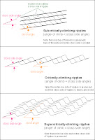
Today we are gonna look at some ripple cross-laminated sandstone. More specifically these are called 'climbing ripples', or sometimes you may see this sedimentary structure referred to as 'ripple drift'. These show up particularly nice in this photo because of the light-dark contrast of the sandy vs. muddy laminae.

Climbing ripples record both migration (lateral) and aggradation (vertical) of the bedform. In this example note the very prominent ripple set in the middle section of the photo nicely showing the 'climb' from left to right. Different angles of climb represent different ratios of migration and aggradation. Climbing ripples are commonly interbedded with or grade upwards into wavy laminae.


This image at left is a classification of types of climbing ripple-laminated structures based on the angle of climb (click on image for larger view; click here for source of image).

Climbing ripples are most commonly seen in river and turbidity current deposits, typically in sub-environments of high rates of deposition from decelerating flows.


On a side note, Dr. Lemming has pointed out a new geology-related blog out there. It's called All of My Faults Are Stress Related and looks to be a nice addition to the geoblogosphere. I have a few more new links over there on the sidebar that i'll post about soon.

I also have an updated album of Patagonia photos you can check out here. The above image is from that collection.

Wednesday, May 23, 2007

Visualizing complex networks

I came across this interesting website, called Visual Complexity, that has a collection of images from various projects that aim to map and produce visualizations of complex networks. These include biological, computer systems, social networks, the web itself, and others.

The image below is a map of the blogosphere from here.

The value of these to me aren't so much in using them as a map....as in to navigate the blogosphere with the above image....but to appreciate the nature of networks.

Friday, May 11, 2007

Catalina Island wildfire

If you're following the news even a little bit, you've probably heard about the wildfire burning up Catalina Island, which is offshore of southern California. Click image above or quote below to read story and see more photos. Although many people live on the island, much of it is a wildlife refuge.

Despite being well offshore, Catalina has been left parched by the lack of rainfall that has made the rest of Southern California particularly susceptible to wildfires like the one in Los Angeles' Griffith Park this week.


Here is a batymetric map showing the island. See more here.

Wednesday, May 02, 2007

Stunning new images of Jupiter and its moons


NASAs New Horizons spacecraft, which is on its way to Pluto, returned some incredible new images of Jupiter and its satellites. Check out the entire BBC article here and go here for more images.

The craft was using Jupiter as a slingshot to get out to the outer solar system as was able to get these images during the process. The above image shows the Little Red Spot (which is as big as Earth), a gigantic storm that scientists have had their eye on for some time.

The image below shows the moon Io in the upper left. The blue plume is from the erupting Tvashtar volcano. Europa, which has amazingly different characteristics is seen in the lower right.

Thursday, April 26, 2007

Structural deformation revealed on sea-floor image

As you've seen from previous posts on this blog (e.g., here, here, and here) I have a penchant for images of sea-floor bathymetry. Not only are they fascinating (and aesthetically pleasing) but they constantly remind of us of how much we don't know about our own planet surface (remember, 2/3 of the Earth's surface is under water). We have mapped the surface of Mars better than Earth!

A recent Deep Sea News post reminded me of a great web resource if you are interested in marine science. It is called SIMoN, which stands for Sanctuary Integrated Monitoring Network, is a portal for all things related to the Monterey Bay National Marine Sanctuary. Much of the site involves the biological and habitat aspects (it is a sanctuary after all) but there is also great stuff regarding the geology and geomorphology of the area.

The image below (see page on SIMoN here for all the details) is from an area offshore of the central California near Half Moon Bay (just south of San Francisco and north of Santa Cruz). This area is called Mavericks and is a popular surfing spot.


What is most striking is how nicely the structural deformation of Pliocene sedimentary rocks is shown with this image. Movement on the San Gregorio fault (a wholly owned subsidiary of the San Andreas) has produced this folding and the layered nature of the strata has resulted in the differential erosion and alternating ridges and 'valleys' seen on the bathymetry.

Friday, April 20, 2007

Friday Field Foto #13: Permian rocks of the Delaware Mts

This is from west Texas (my old master's degree stompin' grounds). The Permian Brushy Canyon Formation is the sandstone and siltstone making up the foreground cliffs. In the background, along the skyline, is the Guadalupe Mountains, which is the highest point in Texas.

The geology of this area is very unique in that these mountains expose a shelf, shelf-margin, and basin transition across ~100 km nearly continuously. One of these days, I'll post some more info about that.

This photo taken by and courtesy of my friend Marieke

Thursday, April 12, 2007

Inverted depositional features on Mars

FYI - this post is not about brand new discoveries -- you can find information about these features on Mars Global Surveyor website and also check out a Science paper from 2003 by Malin et al. that goes over this stuff in more detail...I just felt like posting about it.

I was living in Colorado some years back when I went on a trip to look at the local geology of the Front Range and had one of those great field moments when the trip leader pointed out some inverted topography. In this case, a relatively small volcanic eruption produced lava flows that were isolated in a mountain valley. Since that time, the surrounding much softer sediments and sedimentary rocks have eroded away leaving lava-capped mesas that are now segmented by the modern river. The image below is of Golden showing the modern Clear Creek cutting the lava-capped mesa in two (yes, that complex of structures right in the valley is Coors brewery). Image courtesey of www.tablemountains.org.

These modern positive topographic features are representing an ancient valley! Very cool.

So, while wasting time on the internet - in 7-minute increments - I came across some old bookmarks about some inverted topographic features on Mars. The group of features, discovered in November 2003 by Mars Global Surveyor (MGS), have been dubbed the Eberswalde Delta.

The image above is Fig. 2 straight from Malin et al. (2003) showing the exhumed fluvial distributary fan (click on all images for larger view). The conspicuous curvilinear features at closer examination are actually positive topography. Inset of box A below clearly shows the deposits of a migrating meandering stream standing as a plateau above the surrounding area.

This is a striking example of inverted topography. In this case, the channel deposits contain coarser material (likely sand/gravel) and therefore are more resistant than the out-of-channel material (likely mud/silt). No data from the planet surface exists for this location but these are reasonable guesses. The cross-cutting relationships of this feature also nicely reveal that the wide meander swing was abandonded for a shorter, more direct route at some point.

The image below (inset box B) shows more cross-cutting ridges representing channel-fill deposits. I would sure like to walk up the edges of those ridges and plateaus to check out the cross-section of that fill. Another thing to notice is the apparent spreading out of coarser-grained material from left to right. Malin et al. interpret this as the lobe deposits at the end of these channel features....which seems pretty reasonable to me.


The implications of all this, of course, are further evidence of flowing water on Mars. The big problem we are faced with at this point is not so much if water flowed on Mars, but when. The next generation of rovers are gonna half to brush up on their geochronology.

Thursday, March 29, 2007

Giant sandy bedforms seaward of the Golden Gate Bridge

High-resolution sea-floor mapping done in 2004 and 2005 by the US Geological Survey (USGS) and Cal State Monterey Bay (CSUMB) reveals a field of gigantic sand waves just west of the Golden Gate of San Francisco Bay.

More than 40 large sand waves were mapped, with crest-to-crest lengths of as much as 220 meters and heights of as much as 10 meters. Although the tidal range is not huge here, the narrowness of the Golden Gate straight augments the tidal force significantly (tidal currents > 2.5 m/s). Note in perspective bathymetric images how the area directly under the bridge (blue/purple colors) is kept clean of sediment.


Here is a short synopsis from the USGS's website.

Here is an article from the San Francisco Chronicle from last summer.

Check this out for another submarine view of San Francisco Bay.

Tuesday, March 27, 2007

Giant selenite crystals

Some of you may have seen these photos....they have been circulating via e-mail over the last few weeks.

Pretty amazing....probably the largest selenite (CaSO4·2H2O) crystals found, i'd imagine. Miners discovered them in Naica Mine, Chihuahua, Mexico. Note people for scale in photos.


Sunday, March 25, 2007

Photographic summary of recent Patagonia field work

I am putting together a post about the general geology of the region of southern Chile we work in, what we are working on exactly, etc. but is taking a lot longer than I'd like.
As most of you out there who do relatively long stints of field work you know how it is getting your non-geology life back in order when you get home.

In the meantime, here a some photos and superficial information about them, and anecdotes from this year's session. (Click on photos for hi-res versions).

The above photo illustrates one reason why we travel so far to look at sedimentary rocks -- the exposure. Much of the stratigraphic section we are investigating is shale/siltstone, which does not typically create great outcrops. In this area, however, the recent glaciation has 'cleaned up' the mountainsides giving us a glimpse of these strata. You'll notice in the bottom portion of this exposure an odd lens-shaped area....this section is riddled with deep-sea mass wasting deposits (slumps, slides, debris flow deposits, etc.). The interior of that lens-shaped area is chaotically folded and deformed (syn-sed, soft deformation). There are very few places in the world where this kind of syn-sedimentary deformation is this well-exposed. The photo below is zoomed in a bit. Note the discordant strata in the lower half.


For this particular study area we were lucky to be able to stay in a nice little puesto...a glorified shack where the gauchos stay when they are in the area tending to sheep (see below). Not that I dislike camping...but when working, it is nice to come back to a roof and wood-burning stove in the evening. Plus, being able to drive to the puesto allows us to bring additional supplies (i.e., wine).


Up until this year, all of the work i've done in this area has been near, but outside of the national park boundaries (Torres del Paine). A new student is starting a project looking at the structure and thermal/exhumation history of the fold-thrust belt. This requires going further west into the more deformed part of the belt and thus towards the Patagonia ice cap (the 3rd largest continental ice sheet after Antarctica and Greenland, I believe). As you can imagine, accessibility is a major issue....the roads/trails within the park remain the best way to access a lot of these rocks efficiently, safely, and cheaply. So...the bonus is the spectacular scenery. The photo below is from our campsite early one morning...if you've ever read anything about this area you've no doubt seen this image. It is, by far, the most iconic image of this massif...called Los Cuernos (or 'horns').

The light rocks are the granitoid laccolith rocks intruding into the dark shales of the sedimentary sequence we are studying. The sed sequence is Upper Cretaceous...the laccolith is Miocene...I promise I'll get a post going putting all this random geo-info into some context. By the way, the water in the foreground is essentially sea level and the top of those peaks are nearly 3,000 m (10,000 ft). A little bit of relief.

Another day we were sampling along a trail that led to Glacier Grey. We, of course, had the proper permission and paperwork for sampling in the park, but still got many curious (and some dirty) looks from tourists along the trail. I suppose we may have been ruining their solitude by hammering away....but, hey, tough break. But most people were simply curious and once they find out we are scientists they will ask questions about the area. This photo below is a view of the glacier during our lunch break.

The geologic map of this area that we have is from the late 1970s. Note the two rock 'islands' at the glacier front...the bigger one to the right and the much smaller to the left in the photo above. The smaller one is not on the 30 year old map...the glacier has retreated that much.

After this work, me and one other guy set out for an excursion to a rather remote area in an area northeast of the park (again...I will post about the geography/geology more properly sometime soon). I've been working in this area for 4 years, but this was the first time to this particular area. It required being horse-packed in and camping for 10 days. Essentially, a gaucho guide takes us in, drops us off, and then comes back on a specific day to retrieve us. I shot this photo (see below) of the gaucho leaving the canyon we were in after dropping us off. He was much more efficient in traveling once he got rid of the two gringos (not necessarily master horseman) and all the supplies.


This was one of the harder areas i've worked physically. We couldn't really get too close to the outcrop we wanted to work on with the horses due the the ruggedness of the canyon we were in. So, we had a 5 km cross-country hike every day to the rocks (about 4 hours). By the end of the excursion we were not only in better shape but had found a good network of game trails that made the commute not so hard on our bodies.
Now that I'm sitting comfortably at home and not cursing my blistered feet and shaking a fist angrily at the weather gods, I can say it was worth it. The sedimentary sequence we were investigating in this area is important to the overall understanding of the basin fill because it is the record of delta progradation that eventually constructs the shelf and fills in the deep-water foreland during the latest Cretaceous. So, in a short sequence we saw turbidites intermingling with hummocky cross-stratification (wave-base) and deltaic deposits. This is another student's research, so I'm not gonna steal his thunder by posting too much about it....stay tuned.

On a nice day, we got this view from the top of the outcrop (photo above). The tops of those mountains in the distance (to the west) is the Patagonia ice cap...it's a few km thick in that area...or something like that.

Stay tuned for a post with more geology and context for all of this.

Friday, February 16, 2007

Friday Field Foto #11: Guanaco

I am headed down south again very soon (next Tues) for my last field season in Patagonia...as a student anyway. I've had one other post about wildlife we encounter down there.

The above animal is a guanaco, which is sort of like a cross between a llama and a camel. These things are all over the place. We were able to get close to this particular one because we were in Parque Nacional Torres del Paine, where they are tamer. When we see them in other areas outside of the park, they keep their distance. Typically one of them will stand between us and the rest of the herd...keeping the herd informed on what we are doing. Guanacos make a noise that sounds like a horse whinney combined with a laughing hyena.

Whenever we see them, we wish we could ride them up the mountain...they can get up the hills a lot faster than us.

Monday, February 05, 2007

JSW #2: Submarine Geomorphology

This is the second post for the Just Science week (Feb 5th-9th) on ...Or Something.
See the first post here.


from USGS; see more here

The resolution and coverage of both sea-floor mapping and subsurface seismic-reflection technology has grown by leaps and bounds over the last couple of decades. The above image is a perspective image of the Los Angeles, California area onshore topography and offshore bathymetry. Note the relatively flat continental shelf (green), very defined shelf edge, and variably steep continental slope leading to the deep sea (dark purple). The shelf edge and shelf is incised by submarine canyons that deliver terrigenous (i.e., derived from continent) sediment to the deep ocean. Many of these canyons and channels are sitting out at the shelf edge and are inactive now. During Last Glacial Maximum (~18,000 years ago) sea levels were much lower and the shoreline was essentially at the shelf edge. Some of these canyons are still active at present, however. On Friday of this week I will have a post about research I've been doing recently studying the flux of terrigenous sediment to one of these basins.


get original image here

This next image (above) is a map-view of the bathymetry offshore of Monterey, California (please check out MBARI's website for more great images of the sea floor). Monterey Bay is in the upper right of the image with the head of Monterey submarine canyon smack-dab in the middle between Santa Cruz to the north and the town of Monterey to the south. Monterey Canyon is a huge feature...follow it out seaward and the canyon transitions into a submarine channel with a beautiful meander that's barely on this image. The distance from the canyon head to that meander, called Shepherd Meander, is approximately 125 km (75 mi) to give you a sense of scale. The water depth at that meander is approximately 3400 m (11,150 ft). Monterey Canyon is one of the most studied and well monitored submarine canyons in the world. Turbulent gravity-driven flows carrying a lot of sand are responsible for carving out this fantastic feature over long time scales (hundreds of thousands to millions of years). This paper from 2004 by colleagues of mine, Andrea Fildani and Bill Normark, is a great resource for understanding the geologic history and sedimentary processes related to the formation of Monterey Canyon.


Three-dimensional seismic-reflection technology allows us to create maps of buried geomorphic features. The images shown at right and below clearly show beautiful meandering channels that were once on the sea floor (in very deep water) and are now in the subsurface. By analyzing 'slices' within the seismic volume we can map the evolution of the geomorphology through time. These images from a recent paper from Posamentier & Kolla (2003).


Utilized together, bathymetric images from the modern sea floor and seismic-reflection images from the buried sea floor are spawning new branches of geomorphology that are focused on deep-marine processes and evolution. I envision more and more collaborative efforts in the future among subaerial (i.e., on land) and submarine researchers of Earth surface processes.


Posamentier and Kolla, 2003, Seismic geomorphology and stratigraphy of depositional elements in deep-water settings, Journal of Sedimentary Research, Vol. 73, No. 3